NEPAL
Geography: A landlocked country the size of Arkansas, lying between India and the Tibetan Autonomous Region of China, Nepal contains Mount Everest (29,035 ft; 8,850 m), the tallest mountain in the world. Along its southern border, Nepal has a strip of level land that is partly forested, partly cultivated. North of that is the slope of the main section of the Himalayan range, including Everest and many other peaks higher than 8,000 m.
Government: In Nov. 1990, King Birendra promulgated a new constitution and introduced a multiparty parliamentary democracy in Nepal. Under pressure amid massive pro-democracy protests in April 2006, King Gyanendra gave up direct rule and reinstated Parliament, which then quickly moved to diminish the King's power. In Dec. 2007, Parliament voted to abolish the monarchy and become a federal democratic republic. The transition to a republic was completed in May 2008, when the Constituent Assemby voted to dissolve the monarchy.
History: The first civilizations in Nepal, which flourished around the 6th century B.C. , were confined to the fertile Kathmandu Valley where the present-day capital of the same name is located. It was in this region that Prince Siddhartha Gautama was born c. 563 B.C. Gautama achieved enlightenment as Buddha and spawned Buddhism.
Nepali rulers' early patronage of Buddhism largely gave way to Hinduism, reflecting the increased influence of India, around the 12th century. Though the successive dynasties of the Gopalas, the Kiratis, and the Licchavis expanded their rule, it was not until the reign of the Malla kings from 1200–1769 that Nepal assumed the approximate dimensions of the modern state.
The kingdom of Nepal was unified in 1768 by King Prithvi Narayan Shah, who had fled India following the Moghul conquests of the subcontinent. Under Shah and his successors, Nepal's borders expanded as far west as Kashmir and as far east as Sikkim (now part of India). A commercial treaty was signed with Britain in 1792 and again in 1816 after more than a year of hostilities with the British East India Company.
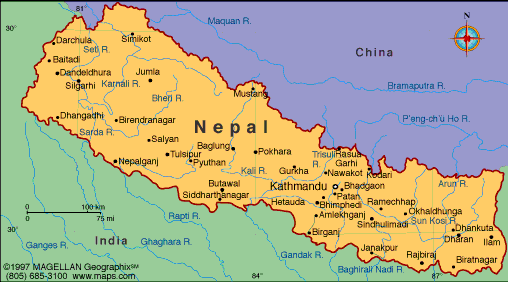
Map of Nepal
President: Ram Baran Yadav (2008)
Prime Minister: Sushil Koirala (2014)
Land area: 52,819 sq mi (136,801 sq km);
total area: 54,363 sq mi (140,800 sq km)
Population (2014 est.): 30,986,975
(growth rate: 1.82 birth rate: 21.07/1000; infant mortality rate:
40.43/1000; life expectancy: 67.19
Capital and largest city (2011 est.):
Kathmandu, 1.015 million
Other large cities: Biratnagar,
174,600; Lalitpur, 169,100
Monetary unit: Nepalese rupee
Languages:
Nepali (official) 44.6%, Maithali 11.7%, Bhojpuri 6%,
Tharu 5.8%, Tamang 5.1%, Newar 3.2%, Magar 3%, Bajjika 3%, Urdu 2.6%,
Avadhi 1.9%, Limbu 1.3%, Gurung 1.2%, other 10.4%, unspecified 0.2%
note: 123 languages reported as mother tongue in 2011 national census; many in government and business also speak English (2011 est.)
Ethnicity/race:
Chhettri 16.6%, Brahman-Hill 12.2%, Magar 7.1%, Tharu
6.6%, Tamang 5.8%, Newar 5%, Kami 4.8%, Muslim 4.4%, Yadav 4%, Rai 2.3%,
Gurung 2%, Damai/Dholii 1.8%, Thakuri 1.6%, Limbu 1.5%, Sarki 1.4%,
Teli 1.4%, Chamar/Harijan/Ram 1.3%, Koiri/Kushwaha 1.2%, other 19%
note: 125 caste/ethnic groups were reported in the 2011 national census (2011 est.)
Religions:
Hindu 81.3%, Buddhist 9%, Muslim 4.4%, Kirant 3.1%, Christian 1.4%, other 0.5%, unspecifed 0.2% (2011 est.)
Literacy rate: 57.4% (2011 est.)
Economic summary: GDP/PPP (2013
est.): $42.06 billion; per capita $1,500. Real growth rate:
3.6%. Inflation: 9.5% (2012). Unemployment: 46% (2008 est.).
Arable land: 16%. Agriculture: rice, corn, wheat,
sugarcane, root crops; milk, water buffalo meat. Labor force:
16 million; note: severe lack of skilled labor (2011 est.);
agriculture 75%, industry 7%, services 18%. Industries:
tourism, carpet, textile; small rice, jute, sugar, and oilseed
mills; cigarettes, cement and brick production. Natural
resources: quartz, water, timber, hydropower, scenic beauty,
small deposits of lignite, copper, cobalt, iron ore. Exports:
$1.06 billion (2013 est.): carpets, clothing, leather goods, jute
goods, grain. Imports: $6.329 billion (2013 est.):
gold, machinery and equipment, petroleum products, fertilizer.
Major trading partners: India, U.S., Germany, China,
Indonesia (2006).
Communications: Telephones: main lines
in use: 834,000 (2013); mobile cellular: 18.1382 million (2013).
Broadcast media: state operates 2 TV
stations as well as national and regional radio stations; roughly 30
independent TV channels are registered with only about half in regular
operation; nearly 400 FM radio stations are licensed with roughly 300
operational (2007). Internet hosts: 41,256
(2012). Internet users: 577,800 (2009).
Transportation: Railways: total: 59 km
(2008). Roadways: total: 10,844 km; paved: 4,952 km;
unpaved: 5,892 km (2010). Ports and harbors: none.
Airports: 47 (2013).
International disputes: joint border
commission continues to work on small disputed sections of boundary
with India; India has instituted a stricter border regime to
restrict transit of Maoist insurgents.
-------------------- o --------------------
No comments:
Post a Comment