NETHERLANDS
Geography: The Netherlands, on the coast of the North Sea, is twice the size of New Jersey. Part of the great plain of north and west Europe, the Netherlands has maximum dimensions of 190 by 160 mi (360 by 257 km) and is low and flat except in Limburg in the southeast, where some hills rise up to 322 m (1056 ft). About half the country's area is below sea level, making the famous Dutch dikes a requisite for efficient land use. Reclamation of land from the sea through dikes has continued through recent times. All drainage reaches the North Sea, and the principal rivers—Rhine, Maas (Meuse), and Schelde—have their sources outside the country.
Government: Constitutional monarchy.
History: Julius Caesar found the low-lying Netherlands inhabited by Germanic tribes—the Nervii, Frisii, and Batavi. The Batavi on the Roman frontier did not submit to Rome's rule until 13 B.C. , and then only as allies.
The Franks controlled the region from the 4th to the 8th century, and it became part of Charlemagne's empire in the 8th and 9th centuries. The area later passed into the hands of Burgundy and the Austrian Hapsburgs and finally, in the 16th century, came under Spanish rule.
When Philip II of Spain suppressed political liberties and the growing Protestant movement in the Netherlands, a revolt led by William of Orange broke out in 1568. Under the Union of Utrecht (1579), the seven northern provinces became the United Provinces of the Netherlands. War between the United Provinces and Spain continued into the 17th century but in 1648 Spain finally recognized Dutch independence.
The Dutch East India Company was established in 1602, and by the end of the 17th century, Holland was one of the great sea and colonial powers of Europe.
The nation's independence was not completely established until after the Thirty Years' War (1618–1648), when the country's rise as a commercial and maritime power began. In 1688, the English Parliament invited William of Orange, stadtholder, and his wife, Mary Stuart, to rule England as William III and Mary II. William then used the combined resources of England and the Netherlands to wage war on Louis XIV's France. In 1814, all the provinces of Holland and Belgium were merged into one kingdom, but in 1830 the southern provinces broke away to form the kingdom of Belgium. A liberal constitution was adopted by the Netherlands in 1848. The country remained neutral during World War I.
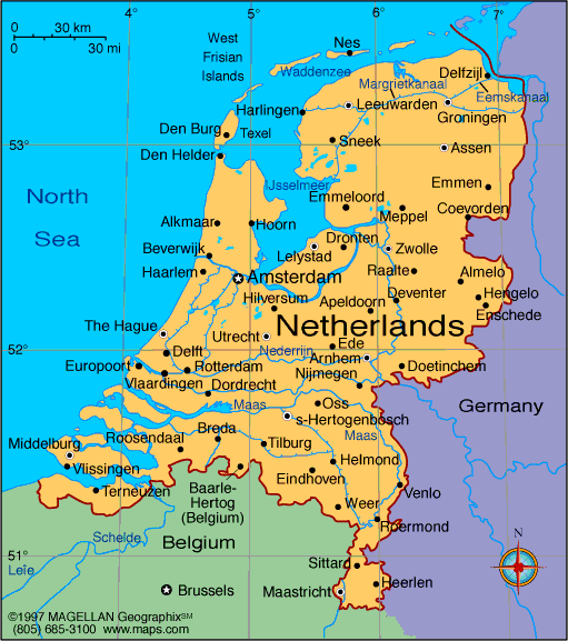
Map of
Netherlands
Sovereign: Willem-Alexander
(2013)
Prime Minister: Mark Rutte (2010)
Land area: 13,104 sq mi (33,939 sq km);
total area: 16,033 sq mi (41,526 sq km)
Population (2014 est.): 16,877,351 (growth
rate: 0.42%); birth rate: 10.83/1000; infant mortality rate: 3.66/1000;
life expectancy: 81.12
Capital and largest city (2011 est.):
Amsterdam (official), 1.056 million; The Hague
(administrative capital), 635,000
Other large cities: Rotterdam, 1.014 million
Monetary unit: Euro (formerly guilder)
National name: Koninkrijk der
Nederlanden
Languages:
Dutch (official)
note: Frisian, Low Saxon, and Limburgish are
recognized as regional languages under the European Charter for Regional
or Minority Languages
Ethnicity/race:
Dutch 80.7%, EU 5%, Indonesian 2.4%, Turkish 2.2%, Surinamese 2%, Moroccan 2%, Caribbean 0.8%, other 4.8% (2008 est.)
Religions:
Roman Catholic 28%, Protestant 19% (includes Dutch
Reformed 9%, Protestant Church of The Netherlands, 7%, Calvinist 3%),
other 11% (includes about 5% Muslim and lesser numbers of Hindu,
Buddhist, Jehovah's Witness, and Orthodox), none 42% (2009 est.)
National Holiday:
Queen's Day, April 30
Literacy rate: 99% (2003 est.)
Economic summary: GDP/PPP (2011 est.):
$699.7 billion; per capita $43,300. Real growth rate: -0.8%.
Inflation: 2.5%. Unemployment: 8.3%. Arable land:
25.08%. Agriculture: grains, potatoes, sugar beets, fruits,
vegetables; livestock. Labor force: 7.939 million; agriculture
2.3%, industry 18.8%, services 78.9% (2011 est.). Industries:
agroindustries, metal and engineering products, electrical
machinery and equipment, chemicals, petroleum, construction,
microelectronics, fishing. Natural resources: natural gas,
petroleum, arable land. Exports: $576.9 billion (2013
est.): machinery and equipment, chemicals, fuels; foodstuffs.
Imports: $511 billion (2013 est.): machinery and
transport equipment, chemicals, fuels, foodstuffs, clothing. Major
trading partners: Germany, Belgium, UK, France, Italy, U.S.,
Russia, China (2012).
Communications:
Telephones: main lines in use: 7.086 million (2012); mobile
cellular: 19.643 million (2012). Broadcast media:
more than 90% of households are connected to cable or satellite TV
systems that provide a wide range of domestic and foreign channels;
public service broadcast system includes multiple broadcasters, 3 with a
national reach and the remainder operating in regional and local
markets; 2 major nationwide commercial television companies, each with 3
or more stations, and many commercial TV stations in regional and local
markets; nearly 600 radio stations with a mix of public and private
stations providing national or regional coverage (2008). Internet hosts: 13.699 million (2012). Internet users: 14.872
million (2009).
Transportation: Railways:
total: 3,013 km (2012). Roadways: total: 139,295 km (includes 2,758 km of expressways) (2012)
. Waterways: 6,237 km
(navigable for ships of 50 tons). Ports and terminals: Amsterdam, IJmuiden, Moerdijk, Rotterdam, Terneuzen, Vlissingen.
Airports: 29 (2013).
International
disputes: none.
-------------------- o --------------------
No comments:
Post a Comment