NICARAGUA
Geography: Largest but most sparsely populated of the Central American nations, Nicaragua borders Honduras to the north and Costa Rica to the south. It is slightly larger than New York State. Nicaragua is mountainous in the west, with fertile valleys. Two big lakes, Nicaragua and Managua, are connected by the Tipitapa River. The Pacific coast is volcanic and very fertile. The swampy Caribbean coast is aptly called the “Mosquito Coast.”
Government: Republic.
History: Nicaragua, which derives its name from the chief of the area's leading Indian tribe at the time of the Spanish Conquest, was first settled by the Spanish in 1522. The country won independence in 1838. For the next century, Nicaragua's politics were dominated by the competition for power between the Liberals, who were centered in the city of León, and the Conservatives, centered in Granada.
To back up its support of the new Conservative government in 1909, the U.S. sent a small detachment of marines to Nicaragua from 1912 to 1925. The Bryan-Chamorro Treaty of 1916 (terminated in 1970) gave the U.S. an option on a canal route through Nicaragua and naval bases. U.S. Marines were sent again to quell disorder after the 1924 elections. A guerrilla leader, Gen. César Augusto Sandino, fought the U.S. troops from 1927 until their withdrawal in 1933.
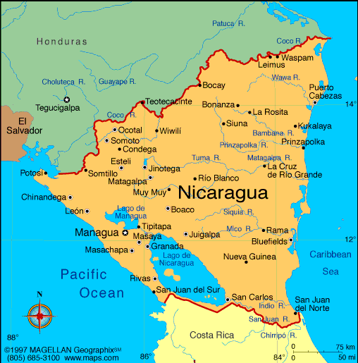
Map of
Nicaragua
President: Daniel Ortega (2007)
Land area: 46,430 sq mi (120,254 sq km);
total area: 49,998 sq mi (129,494 sq km)
Population (2014 est.): 5,848,641 (growth
rate: 1.02%); birth rate: 18.41/1000; infant mortality rate: 20.36/1000;
life expectancy: 72.72
Capital and largest city (2011 est.):
Managua, 970,000
Monetary unit: Gold
cordoba
National
name: República de Nicaragua
Languages:
Spanish (official) 95.3%, Miskito 2.2%, Mestizo of the Caribbean coast 2%, other 0.5%; English and indigenous
languages on Atlantic coast (2005)
Ethnicity/race:
mestizo 69%, white 17%, black 9%, Amerindian
5%
Religions:
Roman Catholic 58.5%, Protestant 23.2% (Evangelical
21.6%, Moravian 1.6%), Jehovah's Witnesses 0.9%, other 1.6%, none 15.7%
(2005 est.)
National Holiday:
Independence Day, September 15
Literacy rate: 78% (2005 est.)
Economic summary: GDP/PPP (2013 est.):
$27.97 billion; per capita $4,500. Real growth rate: 4.6%.
Inflation: 5.7%. Unemployment: 7.2% (2013)
note: underemployment was 46.5% in 2008. Arable land: 14.57%.
Agriculture: coffee, bananas, sugarcane, cotton, rice, corn,
tobacco, sesame, soya, beans; beef, veal, pork, poultry, dairy
products; shrimp, lobsters. Labor force: 3.039 million;
agriculture 31%, industry 18%, services 50% (2006 est.).
Industries: food processing, chemicals, machinery and metal
products, textiles, clothing, petroleum refining and distribution,
beverages, footwear, wood. Natural resources: gold, silver,
copper, tungsten, lead, zinc, timber, fish. Exports: $2.401
billion (2013 est.): coffee,
beef, shrimp and lobster, tobacco, sugar, gold, peanuts.
Imports: $5.65 billion (2013 est.): consumer goods,
machinery and equipment, raw materials, petroleum products. Major
trading partners: U.S., El Salvador, Canada, Costa Rica,
Venezuela (2013).
Communications: Telephones: main lines in
use: 320,000 (2012); mobile cellular: 5.346 million (2012). Broadcast media:multiple
privately owned terrestrial TV networks, supplemented by cable TV in
most urban areas; of more than 100 radio stations, nearly all are
privately owned; Radio Nicaragua is government-owned and Radio Sandino
is controlled by the Sandinista National Liberation Front (FSLN) (2007).
Internet hosts: 296,068 (2012). Internet users: 199,800 (2009).
Transportation: Railways: 6 km (2006).
Roadways: total: 23,897 km; paved: 3,282 km; unpaved: 20,615 km
(2011). Waterways: 2,220 km (including 2 large lakes). Ports
and harbors: Bluefields, Corinto. Airports: 147 (2013).
International disputes:
the 1992 (International Court of Justice) ICJ ruling for El Salvador
and Honduras advised a tripartite resolution to establish a maritime
boundary in the Gulf of Fonseca, which considers Honduran access to the
Pacific; Nicaragua and Costa Rica regularly file border dispute cases
over the delimitations of the San Juan River and the northern tip of
Calero Island to the ICJ; in 2009, the ICJ ruled that Costa Rican
vessels carrying out police activities could not use the river, but
official Costa Rican vessels providing essential services to riverside
inhabitants and Costa Rican tourists could travel freely on the river;
in 2011, the ICJ provisionally ruled that both countries must remove
personnel from the disputed area; in 2013, the ICJ rejected Nicaragua's
2012 suit to halt Costa Rica's construction of a highway paralleling the
river on the grounds of irreparable environmental damage; in 2013, the
ICJ, regarding the disputed territory, ordered that Nicaragua should
refrain from dredging or canal construction and refill and repair damage
caused by trenches connecting the river to the Caribbean and upheld its
2010 ruling that Nicaragua must remove all personnel; in early 2014,
Costa Rica brought Nicaragua to the ICJ over offshore oil concessions in
the disputed region.
-------------------- o --------------------
No comments:
Post a Comment