NIGER
Geography: Niger, in West Africa's Sahara region, is four-fifths the size of Alaska. It is surrounded by Mali, Algeria, Libya, Chad, Nigeria, Benin, and Burkina Faso. The Niger River in the southwest flows through the country's only fertile area. Elsewhere the land is semiarid.
Government: Republic, emerging from military rule.
History: The nomadic Tuaregs were the first inhabitants in the Sahara region. The Hausa (14th century), Zerma (17th century), Gobir (18th century), and Fulani (19th century) also established themselves in the region now called Niger.
Niger was incorporated into French West Africa in 1896. There were frequent rebellions, but when order was restored in 1922, the French made the area a colony. In 1958, the voters approved the French constitution and voted to make the territory an autonomous republic within the French Community. The republic adopted a constitution in 1959 but the next year withdrew from the Community, proclaiming its independence.
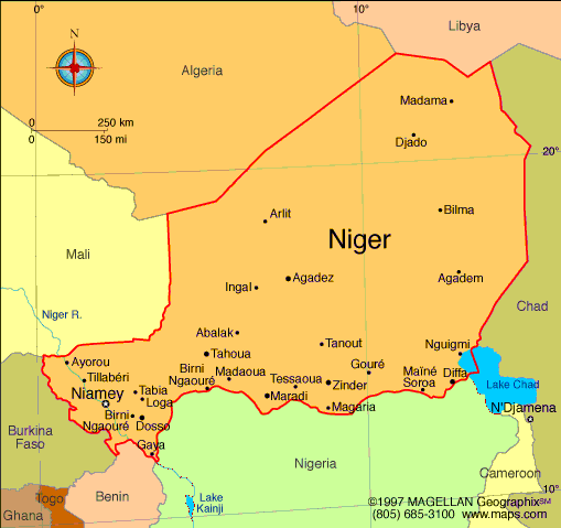
Map of Niger
President: Mahamadou Issoufou (2011)
Prime Minister: Brigi Rafini (2011)
Land area: 489,072 sq mi (1,266,699 sq
km); total area: 489,189 sq mi (1,267,000 sq km)
Population (2014 est.): 17,466,172 (growth
rate: 3.28%); birth rate: 46.12/1000; infant mortality rate: 86.27/1000;
life expectancy: 54.74
Capital and largest city (2011 est.):
Niamey, 1.297 million
Other large cities: Zinder, 202,300;
Maradi, 189,000
Monetary unit: CFA
Franc
National
name: République du Niger
Languages:
French (official), Hausa, Djerma
Ethnicity/race:
Haoussa 55.4%, Djerma Sonrai 21%, Tuareg 9.3%, Peuhl 8.5%, Kanouri Manga 4.7%, other 1.2% (2001 census)
Religions:
Islam 80%, indigenous beliefs and Christian
20%
National Holiday:
Republic Day, December 18
Literacy rate: 28.7% (2005 est.)
Economic summary: GDP/PPP (2013 est.):
$13.98 billion; per capita $800. Real growth rate: 6.2%.
Inflation: 1.9%. Unemployment: n.a. Arable land:
11.79%. Agriculture: cowpeas, cotton, peanuts, millet,
sorghum, cassava (tapioca), rice; cattle, sheep, goats, camels,
donkeys, horses, poultry. Labor force: 4.688 million (2007 est.); agriculture 90%, industry and commerce
6%, government 4%. Industries: uranium mining, cement, brick,
soap, textiles, food processing, chemicals, slaughterhouses.
Natural resources: uranium, coal, iron ore, tin, phosphates,
gold, petroleum. Exports: $1.539 billion (2013): uranium
ore, livestock, cowpeas, onions. Imports: $2.314 billion
(2013): foodstuffs, machinery, vehicles and parts, petroleum, cereals.
Major trading partners: France, Nigeria, U.S., French
Polynesia, Côte d'Ivoire, China, Togo, Ghana, India, Italy (2012).
Communications: Telephones: main lines in
use: 100,500 (2012); mobile cellular: 5.4 million (2012). Broadcast media:
state-run TV station; 3 private TV stations provide a mix of local and
foreign programming; state-run radio has only radio station with a
national reach; about 30 private radio stations operate locally; as many
as 100 community radio stations broadcast; transmissions of multiple
international broadcasters are available (2007). Internet hosts: 454 (2012). Internet users: 115,900 (2009).
Transportation: Railways: 0 km. Roadways:
total: 18,949 km; paved: 3,912 km; unpaved: 15,037 km (2010).
Waterways: the Niger is navigable 300 km from Niamey to Gaya on
the Benin frontier from mid-December through March. Ports and
harbors: none. Airports: 30 (2013).
International disputes:
Libya claims about 25,000 sq km in a currently dormant dispute in the
Tommo region; location of Benin-Niger-Nigeria tripoint is unresolved;
only Nigeria and Cameroon have heeded the Lake Chad Commission's
admonition to ratify the delimitation treaty that also includes the
Chad-Niger and Niger-Nigeria boundaries; the dispute with Burkina Faso
was referred to the ICJ in 2010.
-------------------- o --------------------
No comments:
Post a Comment