NIGERIA
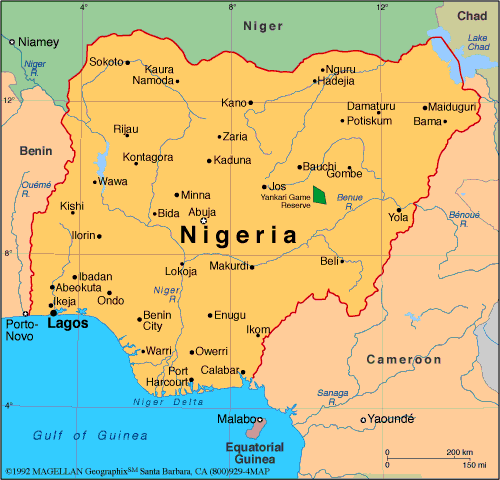
Geography: Nigeria, one-third larger than Texas and the most populous country in Africa, is situated on the Gulf of Guinea in West Africa. Its neighbors are Benin, Niger, Cameroon, and Chad. The lower course of the Niger River flows south through the western part of the country into the Gulf of Guinea. Swamps and mangrove forests border the southern coast; inland are hardwood forests.
Government: Multiparty government transitioning from military to civilian rule.
History: The first inhabitants of what is now Nigeria were thought to have been the Nok people (500 BC –c. AD 200). The Kanuri, Hausa, and Fulani peoples subsequently migrated there. Islam was introduced in the 13th century, and the empire of Kanem controlled the area from the end of the 11th century to the 14th.
The Fulani empire ruled the region from the beginning of the 19th century until the British annexed Lagos in 1851 and seized control of the rest of the region by 1886. It formally became the Colony and Protectorate of Nigeria in 1914. During World War I, native troops of the West African frontier force joined with French forces to defeat the German garrison in Cameroon.
Map of Nigeria
President: Muhammadu Buhari
(2015)
Land area: 351,649 sq mi (910,771 sq km);
total area: 356,667 sq mi (923,768 sq km)
Population (2014 est.): 177,155,754
(growth rate: 2.47%); birth rate: 38.03/1000; infant mortality rate:
74.09/1000; life expectancy: 52.62
Capital (2011 est.):
Abuja, 2.153 million
Largest cities: Lagos (2011 est.),
11.223 million; Kano, 3.375 million;
Ibadan, 2.949; Port Harcourt 1.894 million; Kaduna, 1.524 million
Monetary unit: Naira
Languages:
English (official), Hausa, Yoruba, Igbo (Ibo), Fulani, over 500 additional indigenous languages
Ethnicity/race:
More than 250 ethnic groups, including Hausa
and Fulani 29%, Yoruba 21%, Ibo 18%, Ijaw 10%, Kanuri 4%, Ibibio
3.5%, Tiv 2.5%
Religions:
Islam 50%, Christian 40%, indigenous beliefs
10%
National Holiday:
Independence Day (National Day), October 1
Literacy rate: 61.3% (2010 est.)
Economic summary: GDP/PPP (2013
est.): $478.5 billion; per capita $2,800 Real growth rate:
6.2%. Inflation: 8.7%. Unemployment: 23.9%. Arable
land: 38.97%. Agriculture: cocoa, peanuts, palm oil, corn,
rice, sorghum, millet, cassava (tapioca), yams, rubber; cattle,
sheep, goats, pigs; timber; fish. Labor force: 51.53 million;
agriculture 70%, industry 10%, services 20% (1999 est.).
Industries: crude oil, coal, tin, columbite; palm oil,
peanuts, cotton, rubber, wood; hides and skins, textiles, cement and
other construction materials, food products, footwear, chemicals,
fertilizer, printing, ceramics, steel, small commercial ship
construction and repair. Natural resources: natural gas,
petroleum, tin, columbite, iron ore, coal, limestone, lead, zinc,
arable land. Exports: $55.98 billion (2009 est.):
petroleum and petroleum products 95%, cocoa, rubber. Imports:
$55.98 billion (2013 est.): machinery, chemicals,
transport equipment, manufactured goods, food and live animals.
Major trading partners: U.S., Brazil, Spain, China, UK,
Netherlands, France, Germany (2012).
Member of Commonwealth of Nations
Communications: Telephones: main lines
in use: 418,000 (2012); mobile cellular: 112.78 million
(2012). Broadcast media: nearly 70 federal
government-controlled national and regional TV stations; all 36 states
operate TV stations; several private TV stations operational; cable and
satellite TV subscription services are available; network of federal
government-controlled national, regional, and state radio stations;
roughly 40 state government-owned radio stations typically carry their
own programs except for news broadcasts; about 20 private radio
stations; transmissions of international broadcasters are available
(2007). Internet hosts: 1,234 (2012).
Internet users: 43.989 million (2009).
Transportation: Railways: total: 3,505
km (2008). Roadways: total: 193,200 km; paved: 28,980 km; unpaved: 164,220 km (2004
est.). Waterways: 8,600 km (Niger and Benue rivers and
smaller rivers and creeks) (2011). Ports and harbors:
Bonny Inshore Terminal, Calabar, Lagos. Airports:
54 (2013).
International disputes: Joint
Border Commission with Cameroon reviewed 2002 ICJ ruling on the entire
boundary and bilaterally resolved differences, including June 2006
Greentree Agreement that immediately cedes sovereignty of the Bakassi
Peninsula to Cameroon with a phase-out of Nigerian control within two
years while resolving patriation issues; the ICJ ruled on an
equidistance settlement of Cameroon-Equatorial Guinea-Nigeria maritime
boundary in the Gulf of Guinea, but imprecisely defined coordinates in
the ICJ decision and a sovereignty dispute between Equatorial Guinea and
Cameroon over an island at the mouth of the Ntem River all contribute
to the delay in implementation; only Nigeria and Cameroon have heeded
the Lake Chad Commission's admonition to ratify the delimitation treaty
which also includes the Chad-Niger and Niger-Nigeria boundaries;
location of Benin-Niger-Nigeria tripoint is unresolved.
-------------------- o --------------------
No comments:
Post a Comment