PAKISTAN
Geography: Pakistan is situated in the western part of the Indian subcontinent, with Afghanistan and Iran on the west, India on the east, and the Arabian Sea on the south. The name Pakistan is derived from the Urdu words Pak (meaning pure) and stan (meaning country). It is nearly twice the size of California.
The northern and western highlands of Pakistan contain the towering Karakoram and Pamir mountain ranges, which include some of the world's highest peaks: K2 (28,250 ft; 8,611 m) and Nanga Parbat (26,660 ft; 8,126 m). The Baluchistan Plateau lies to the west, and the Thar Desert and an expanse of alluvial plains, the Punjab and Sind, lie to the east. The 1,000-mile-long (1,609 km) Indus River and its tributaries flow through the country from the Kashmir region to the Arabian Sea.
Government: Military rule was instituted in Oct. 1999; a nominal democracy was declared in June 2001 by the ruling military leader, Pervez Musharraf.
History: Pakistan was one of the two original successor states to British India, which was partitioned along religious lines in 1947. For almost 25 years following independence, it consisted of two separate regions, East and West Pakistan, but now it is made up only of the western sector. Both India and Pakistan have laid claim to the Kashmir region; this territorial dispute led to war in 1949, 1965, 1971, 1999, and remains unresolved today.
What is now Pakistan was in prehistoric times the Indus Valley civilization (c. 2500–1700 BC ). A series of invaders—Aryans, Persians, Greeks, Arabs, Turks, and others—controlled the region for the next several thousand years. Islam, the principal religion, was introduced in 711. In 1526, the land became part of the Mogul Empire, which ruled most of the Indian subcontinent from the 16th to the mid-18th century. By 1857, the British became the dominant power in the region. With Hindus holding most of the economic, social, and political advantages, the Muslim minority's dissatisfaction grew, leading to the formation of the nationalist Muslim League in 1906 by Mohammed Ali Jinnah (1876–1949). The league supported Britain in the Second World War while the Hindu nationalist leaders, Nehru and Gandhi, refused. In return for the league's support of Britain, Jinnah expected British backing for Muslim autonomy. Britain agreed to the formation of Pakistan as a separate dominion within the Commonwealth in Aug. 1947, a bitter disappointment to India's dream of a unified subcontinent. Jinnah became governor-general. The partition of Pakistan and India along religious lines resulted in the largest migration in human history, with 17 million people fleeing across the borders in both directions to escape the accompanying sectarian violence.
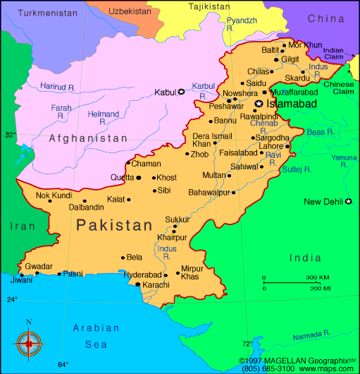
Map of Pakistan
President: Mamnoon Hussain (2013)
Prime minister: Nawaz Sharif
(2013)
Land area: 300,664 sq mi (778,720 sq km);
total area: 310,401 sq mi (803,940 sq km)1
Population (2014 est.): 196,174,380 (growth rate: 1.49%); birth rate: 23.19/1000; infant mortality rate:
57.48/1000; life expectancy: 67.05; density per sq mi: 215
Capital (2011 est.):
Islamabad, 919,000
Largest cities: Karachi 13.876 million; Lahore 7.566 million; Faisalabad 3.038 million; Rawalpindi 2.164 million; Multan 1.775 million (2011)
Monetary unit: Pakistan rupee
Principal languages:
Punjabi 48%, Sindhi 12%, Saraiki (a Punjabi variant) 10%,
Pashto (alternate name, Pashtu) 8%, Urdu (official) 8%, Balochi 3%,
Hindko 2%, Brahui 1%, English (official; lingua franca of Pakistani
elite and most government ministries), Burushaski, and other 8%
Ethnicity/race:
Punjabi 44.68%, Pashtun (Pathan) 15.42%, Sindhi 14.1%, Sariaki 8.38%, Muhajirs 7.57%, Balochi 3.57%, other 6.28%
Religions:
Muslim (official) 96.4% (Sunni 85-90%, Shia 10-15%), other (includes Christian and Hindu) 3.6% (2010 est.)
National Holiday:
Republic Day, March 23
Literacy rate: 54.9% (2009 est.)
Economic summary GDP/PPP
(2013 est.): $574.1 billion; per capita $3,100. Real growth
rate: 3.6%. Inflation: 7.7%. Unemployment: 6.6%
plus substantial underemployment. Arable land: 26.02%.
Agriculture: cotton, wheat, rice, sugarcane, fruits,
vegetables; milk, beef, mutton, eggs. Labor force: 59.21
million; note: extensive export of labor, mostly to the Middle East,
and use of child labor; agriculture 45.1%, industry 20.7%, services 34.2%
(2010 est.). Industries: textiles and apparel, food
processing, pharmaceuticals, construction materials, paper products,
fertilizer, shrimp. Natural resources: land, extensive
natural gas reserves, limited petroleum, poor quality coal, iron
ore, copper, salt, limestone. Exports: $25.05 billion (2013 est.): textiles (garments, bed linen, cotton cloth, yarn),
rice, leather goods, sports goods, chemicals, manufactures, carpets
and rugs. Imports: $39.27 billion (2013 est.):
petroleum, petroleum products, machinery, plastics, transportation
equipment, edible oils, paper and paperboard, iron and steel, tea.
Major trading partners: U.S., UAE, Saudi Arabia, China, Afghanistan, Kuwait (2012).
Communications: Telephones: main lines
in use: 5.803 million (2012); mobile cellular: 125 million (2013).
Broadcast media:media is government
regulated; 1 dominant state-owned TV broadcaster, Pakistan Television
Corporation (PTV), operates a network consisting of 5 channels; private
TV broadcasters are permitted; to date 69 foreign satellite channels are
operational; the state-owned radio network operates more than 40
stations; nearly 100 commercially licensed privately owned radio
stations provide programming mostly limited to music and talk shows
(2007). Internet hosts: 365,813 (2012). Internet users: 20.2431 million
(2009).
Transportation: Railways: total: 7,791
km (2007). Roadways: total: 262,256 km; paved: 189,218 km
(including 708 km of expressways); unpaved: 73,038 km (2010).
Ports and harbors: Karachi, Port Muhammad bin Qasim.
Airports: 151 (2013).
International disputes:
various talks and confidence-building measures cautiously have begun to
defuse tensions over Kashmir, particularly since the October 2005
earthquake in the region; Kashmir nevertheless remains the site of the
world's largest and most militarized territorial dispute with portions
under the de facto administration of China (Aksai Chin), India (Jammu
and Kashmir), and Pakistan (Azad Kashmir and Northern Areas); UN
Military Observer Group in India and Pakistan has maintained a small
group of peacekeepers since 1949; India does not recognize Pakistan's
ceding historic Kashmir lands to China in 1964; India and Pakistan have
maintained their 2004 cease-fire in Kashmir and initiated discussions on
defusing the armed standoff in the Siachen glacier region; Pakistan
protests India's fencing the highly militarized Line of Control and
construction of the Baglihar Dam on the Chenab River in Jammu and
Kashmir, which is part of the larger dispute on water sharing of the
Indus River and its tributaries; to defuse tensions and prepare for
discussions on a maritime boundary, India and Pakistan seek technical
resolution of the disputed boundary in Sir Creek estuary at the mouth of
the Rann of Kutch in the Arabian Sea; Pakistani maps continue to show
the Junagadh claim in India's Gujarat State; since 2002, with UN
assistance, Pakistan has repatriated 3.8 million Afghan refugees,
leaving about 2.6 million; Pakistan has sent troops across and built
fences along some remote tribal areas of its treaty-defined Durand Line
border with Afghanistan, which serve as bases for foreign terrorists and
other illegal activities; Afghan, Coalition, and Pakistan military meet
periodically to clarify the alignment of the boundary on the ground and
on maps.
-------------------- o --------------------
No comments:
Post a Comment