PALAU
Geography: The Palau island chain consists of about 200 islands located in the western Pacific Ocean, 528 mi (650 km) southeast of the Philippines. Only eight of the islands are permanently inhabited. They vary geologically from the high, mountainous, largest island, Babelthuap, to low coral islands, usually fringed by large barrier reefs.
Government: Constitutional republic.
History: The original settlers of Palau are believed to have arrived from Indonesia as early as 2500 BC The Palau islands' position on the western threshold of Oceania and their proximity to Southeast Asia have combined to form a mixed population of Malay, Melanesian, Filipino, and Polynesian ancestry.
Explored by the Spanish navigator Ruy López de Villalobos in 1543, the islands remained under nominal Spanish ownership for more than 300 years before Spain sold them to Germany in 1899. Japan occupied Palau during World War I and received a mandate over them from the League of Nations in 1920. They remained in Japanese control and served as an important naval base until the U.S. seized them during World War II. After the war, the islands became a UN trusteeship (1947), administered by the U.S. Palau signed a Compact of Free Association with the U.S. in 1992, requiring the United States to provide economic aid in exchange for the right to build and maintain U.S. military facilities in Palau. Palau became a sovereign state in 1994.
In 2000, former vice president Tommy Remengesau won the presidential election. In December 2008 presidential elections, former ambassador to Taiwan Johnson Toribiong defeated Vice President Elias Camsek Chin, 51%–49%. In November 2012, Tommy Remengesau was elected to another term as president. Remengesau took office for the second time on January 17, 2013.
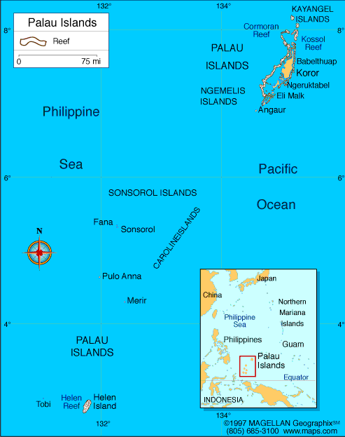
Map of Palau
President: Tommy Remengesau (2013)
Total area: 177 sq mi (458 sq km)
Population (2014 est.): 21,186 (growth
rate: 0.36%); birth rate: 10.95/1000; infant mortality rate:
1.46/1000; life expectancy: 72.6; density per sq mi: 45.5
Capital:
Melekeok, 1,000 (2011)
Largest City:
Koror, 19,000 (2014)
Monetary unit: U.S. dollar used
National name: Beluu er a Belau
Ethnicity/race:
Palauan (Micronesian with Malayan and
Melanesian admixtures) 72.5%, Filipino 16.3%, Chinese 1.6%, other
Asian 3.4%, white 0.9%, Carolinian 1%, Vietnamese 1.6%, other Micronesian 2.4%,
other or unspecified 0.3% (2005 census)
Religions:
Roman Catholic 49.4%, Protestant 30.9%, Modekngei
8.7% (indigenous), Seventh-Day Adventist 5.3%, Jehovah's Witness 1.1%,
other religion 8.8%, unspecified or none 1.1%
(2005 census)
National Holiday:
Constitution Day, July 9
Literacy rate: 92% (2012 est.)
Economic summary: GDP/PPP (2013
est.): $245.5 million; per capita $10,500
(2008 est.). Real growth rate: na% (2005 est.).
Inflation: 2.7% (2011 est.). Unemployment: 4.2% (2005
est.). Arable land: 9%. Agriculture: coconuts, copra,
cassava (tapioca), sweet potatoes; fish. Labor force: 9,777
(2005); agriculture 20%, industry n.a., services n.a. (2004).
Industries: tourism, craft items (from shell, wood, pearls),
construction, garment making. Natural resources: forests,
minerals (especially gold), marine products, deep-seabed minerals.
Exports: $12.3 million f.o.b. (2010 est.): shellfish, tuna,
copra, garments. Imports: $113.4 million f.o.b. (2010 est.):
machinery and equipment, fuels, metals; foodstuffs. Major trading
partners: U.S., Japan, Singapore, Guam, South Korea (2004).
Communications: Telephones: main lines
in use: 7,300 (2012); mobile cellular: 17,150 (2012). Radio
broadcast stations: AM 1, FM 4, shortwave 1 (2002).
Radio Stations: 6 (2009). Television broadcast stations:
1 (cable) (2009). Televisions: 11,000 (1997). Internet
Service Providers (ISPs): 4 (2012). Internet users:
N/A (2012).
Transportation: Railways: 0 km.
Highways: total: 61 km; paved: 36 km; unpaved: 25 km.
Ports and harbors: Koror. Airports: 3 (2013).
International disputes: Maritime delineation negotiations continue with Philippines, Indonesia.
-------------------- o --------------------
No comments:
Post a Comment