PALESTINIAN STATE
Geography: The West Bank is located to the east of Israel and the west of Jordan. The Gaza Strip is located between Israel and Egypt on the Mediterranean coast.
Government: The Palestinian Authority (PA), with Yasir Arafat its elected leader, took control of the newly non-Israeli-occupied areas, assuming governmental duties in 1994.
History: The history of the proposed modern Palestinian state, which is expected to be formed from the territories of the West Bank and Gaza Strip, began with the British Mandate of Palestine. From Sept. 29, 1923, until May 14, 1948, Britain controlled the region, but by 1947, Britain had appealed to the UN to solve the complex problem of competing Palestinian and Jewish claims to the land. In Aug. 1947, the UN proposed dividing Palestine into a Jewish state, an Arab state, and a small international zone. Arabs rejected the idea. As soon as Britain pulled out of Palestine in 1948, neighboring Arab nations invaded, intent on crushing the newly declared State of Israel. Israel emerged victorious, affirming its sovereignty. The remaining areas of Palestine were divided between Transjordan (now Jordan), which annexed the West Bank, and Egypt, which gained control of the Gaza Strip.
Through a series of political and social policies, Jordan sought to consolidate its control over the political future of Palestinians and to become their speaker. Jordan even extended citizenship to Palestinians in 1949; Palestinians constituted about two-thirds of the country's population. In the Gaza Strip, administered by Egypt from 1948–1967, poverty and unemployment were high, and most of the Palestinians lived in refugee camps.
In the Arab-Israeli War of 1967, Israel, over a period of six days, defeated the military forces of Egypt, Syria, and Jordan and annexed the territories of East Jerusalem, the Golan Heights, the West Bank, the Gaza Strip, and all of the Sinai Peninsula. The Palestinian Liberation Organization (PLO), formed in 1964, was a terrorist organization bent on Israel's annihilation. Palestinian rioting, demonstrations, and terrorist acts against Israelis became chronic. In 1974, PLO leader Yasir Arafat addressed the UN General Assembly, the first stateless government to do so. Violence again escalated in 1987 during the intifada (“shaking off”), a new era in Palestinian mass mobilization. In 1988, Yasir Arafat publicly eschewed terrorism and officially recognized the state of Israel.
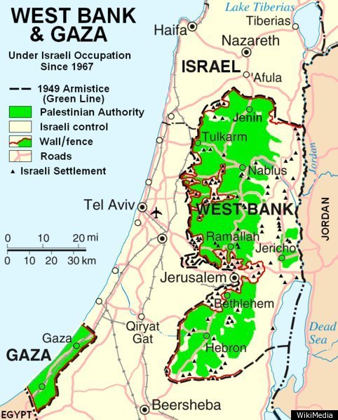
Map of Palestinian
State
West Bank and Gaza Strip
President: Mahmoud Abbas (2005)
Prime Minister: Rami Hamdallah
(2013)
Land area: West Bank: 2,178 sq mi (5,641 sq
km); total area: West Bank: 2,263 sq mi (5,860 sq km); Gaza
Strip: 139 sq mi (360 sq km)
Population (2010 est.): West Bank:
2,514,845, Gaza Strip: 1,604,238 (growth rate: West Bank: 2.1%, Gaza
Strip: 3.3%); birth rate: West Bank: 24.9/1000, Gaza Strip:
36.2/1000; infant mortality rate: West Bank: 15.4/1,000, Gaza Strip:
17.7/1000; life expectancy: West Bank: 74.8, Gaza Strip: 73.7;
density per sq mi: West Bank: 1,164, Gaza Strip: 10,077. NOTE:
figures above include approximately 8,000 Israeli settlers who
evacuated the Gaza Strip in Aug. 2005.
Capital:
Undetermined
Large cities (2003 est.): Gaza,
1,331,600 (metro. area), 407,600 (city proper), Hebron, 137,000;
Nablus, 115,400
Monetary units: New Israeli shekels,
Jordanian dinars, U.S. dollars
Languages:
Arabic, Hebrew, English
Ethnicity/race:
West Bank: Palestinian Arab and other 83%,
Jewish 17%; Gaza Strip: Palestinian Arab and other 99.4%, Jewish
0.6%
Religions:
West Bank: Islam 75% (predominantly Sunni),
Jewish 17%, Christian and other 8%; Gaza Strip: Islam 98.7%
(predominantly Sunni), Christian 0.7%, Jewish 0.6%.
Economic summary: Gaza Strip:
GDP/PPP (2009 est.): $12.8 billion; $2,900 per capita. Real
growth rate: 7%. Inflation: 9.9% (includes West Bank)
(2009). Unemployment: 19% (includes West Bank)
(2009 est.). Arable land: 29%.
Agriculture: olives, citrus, vegetables; beef, dairy
products. Labor force: 278,000 (April–June 2005);
agriculture 11.9%, industry 18%, services 70.1% (April–June
2005). Industries: generally small family businesses that
produce cement, textiles, soap, olive-wood carvings, and
mother-of-pearl souvenirs; the Israelis have established some
small-scale, modern industries in the settlements and industrial
centers. Natural resources: arable land, natural gas.
Exports: $529 million (2008, includes West Bank):
citrus, flowers, textiles (Gaza Strip); olives, fruit, vegetables,
limestone (West Bank). Imports: $3.772 billion (2008,
includes West Bank): food, consumer goods, construction materials.
Major trading partners: Israel, Egypt, West Bank. West
Bank: GDP/PPP (2003 est.): $1.8 billion; $1,100 per capita.
Real growth rate: 6.2% (2004 est.). Arable land:
16.9%. Agriculture: olives, citrus, vegetables; beef, dairy
products. Labor force: 614,000 (April–June 2005);
agriculture 18.4%, industry 24%, services 57.6% (April–June
2005). Natural resource: arable land. Major trading
partners: Israel, Jordan, Gaza Strip (2004).
Communications: Telephones: main lines
in use: 95,729 (total for Gaza Strip and West Bank) (1997); mobile
cellular: Gaza Strip: n.a.; West Bank: n.a. Radio broadcast
stations: Gaza Strip: AM 0, FM 0, shortwave 0; West Bank: AM 1,
FM 0, shortwave 0 (2000). Radios: Gaza Strip: n.a.; West
Bank: n.a.; note: most Palestinian households have radios (1999).
Television broadcast stations: Gaza Strip: 2 (operated by the
Palestinian Broadcasting Corporation) (1997); West Bank: n.a.
Televisions: Gaza Strip: n.a.; West Bank: n.a.; note: most
Palestinian households have televisions (1999). Internet Service
Providers (ISPs): Gaza Strip: 3; West Bank: 8 (1999).
Internet users: 60,000 (total for Gaza Strip and West Bank)
(2001).
Transportation: Railways: Gaza Strip:
total: n.a.; note: one line, abandoned and in disrepair, little
trackage remains; West Bank: 0 km. Highways: Gaza Strip:
total: n.a.; paved: n.a.; unpaved: n.a.; note: small, poorly
developed road network; West Bank: total: 4,500 km; paved: 2,700 km;
unpaved: 1,800 km (1997 est.); note: Israelis have developed many
highways to service Jewish settlements. Ports and harbors:
Gaza Strip: Gaza; West Bank: none. Airports: Gaza Strip: 2
(2001); West Bank: 3 (2002).
International disputes: West Bank and
Gaza Strip are Israeli-occupied with current status subject to the
Israeli-Palestinian Interim Agreement—permanent status to be
determined through further negotiation.
-------------------- o --------------------
No comments:
Post a Comment