PANAMA
Geography: The southernmost of the Central American nations, Panama is south of Costa Rica and north of Colombia. The Panama Canal bisects the isthmus at its narrowest and lowest point, allowing passage from the Caribbean Sea to the Pacific Ocean. Panama is slightly smaller than South Carolina. It is marked by a chain of mountains in the west, moderate hills in the interior, and a low range on the east coast. There are extensive forests in the fertile Caribbean area.
Government: Constitutional democracy.
History: Explored by Columbus in 1502 and by Balboa in 1513, Panama was the principal shipping point to and from South and Central America in colonial days. In 1821, when Central America revolted against Spain, Panama joined Colombia, which had already declared its independence. For the next 82 years, Panama attempted unsuccessfully to break away from Colombia. Between 1850 and 1900 Panama had 40 administrations, 50 riots, 5 attempted secessions, and 13 U.S. interventions. After a U.S. proposal for canal rights over the narrow isthmus was rejected by Colombia, Panama proclaimed its independence with U.S. backing in 1903.
For canal rights in perpetuity, the U.S. paid Panama $10 million and agreed to pay $250,000 each year, which was increased to $430,000 in 1933 and to $1,930,000 in 1955. In exchange, the U.S. got the Canal Zone—a 10-mile-wide strip across the isthmus—and considerable influence in Panama's affairs. On Sept. 7, 1977, Gen. Omar Torrijos Herrera and President Jimmy Carter signed treaties giving Panama gradual control of the canal, phasing out U.S. military bases, and guaranteeing the canal's neutrality.
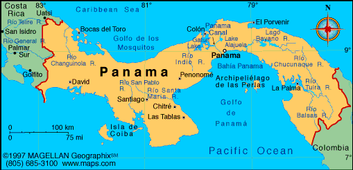
Map of Panama
Land area: 29,340 sq mi (75,991 sq km);
total area: 30,193 sq mi (78,200 sq km)
Population (2014 est.): 3,608,431
(growth rate: 1.35%); birth rate: 18.61/1000; infant mortality rate:
10.7/1000; life expectancy: 78.3; density per sq mi: 140.6
Capital and largest city (2011 est.):
Panama City, 1.426 million
Other large cities: San Miguelito,
321,501; Tocumen, 88,543
Monetary units: balboa; U.S. dollar
National name: República de
Panamá
Ethnicity/race:
mestizo 70%, Amerindian and mixed (West
Indian) 14%, white 10%, Amerindian 6%
Religions:
Roman Catholic 85%, Protestant 15%
Literacy rate: 94.1% (2010 est.)
Economic summary: GDP/PPP (2013
est.): $61.54 billion; per capita $16,500. Real growth rate:
7.5%. Inflation: 4.1%. Unemployment: 4.5%. Arable
land: 7.16%. Agriculture: bananas, rice, corn, coffee,
sugarcane, vegetables; livestock; shrimp. Labor force: 1.54
million; note: shortage of skilled labor, but an oversupply of
unskilled labor (2013 est.); agriculture 17%, industry 18.6%, services
64.4% (2009 est.). Industries: construction, brewing, cement
and other construction materials, sugar milling. Natural
resources: copper, mahogany forests, shrimp, hydropower.
Exports: $18.87 billion (2013 est.): gold, bananas, shrimp, sugar, iron and steel waste, pineapples, watermelons.
Imports: $26.61 billion (2013 est.): fuel products, medicines, vehicles, iron and steel rods, cellular phones.
Major trading partners: U.S., Sweden, Netherlands,
Costa Rica, Mexico, Canada, China, Italy
(2012).
Communications: Telephones: main lines
in use: 640,000 (2012); mobile cellular: 6.77 million (2012).
Radio broadcast stations: AM 80, FM 44, shortwave 0 (2007).
Radios: 815,000 (2007). Television broadcast stations:
38 (including repeaters) (2007). Televisions: 510,000 (1997).
Internet Service Providers (ISPs): 11,022 (2012). Internet
users: 959,800 (2009).
Transportation: Railways: total: 76 km
(2008). Highways: total 15,137 km; paved: 6,351 km; unpaved: 8,786 km (2010).
Waterways: 800 km navigable by shallow
draft vessels; 82 km Panama Canal (2011). Ports and harbors: Balboa,
Cristobal, Colon.
Airports: 117 (2013).
International disputes: none.
-------------------- o --------------------
No comments:
Post a Comment