PHILIPPINES
Geography: The Philippine islands are an archipelago of over 7,000 islands lying about 500 mi (805 km) off the southeast coast of Asia. The overall land area is comparable to that of Arizona. Only about 7% of the islands are larger than one square mile, and only one-third have names. The largest are Luzon in the north (40,420 sq mi; 104,687 sq km), Mindanao in the south (36,537 sq mi; 94,631 sq km), and Visayas (23,582 sq mi; 61,077 sq km). The islands are of volcanic origin, with the larger ones crossed by mountain ranges. The highest peak is Mount Apo (9,690 ft; 2,954 m) on Mindanao.
Government: Republic.
History: The Philippines' aboriginal inhabitants arrived from the Asian mainland around 25,000 BC They were followed by waves of Indonesian and Malayan settlers from 3000 BC onward. By the 14th century AD , extensive trade was being conducted with India, Indonesia, China, and Japan.
Ferdinand Magellan, the Portuguese navigator in the service of Spain, explored the Philippines in 1521. Twenty-one years later, a Spanish exploration party named the group of islands in honor of Prince Philip, who was later to become Philip II of Spain. Spain retained possession of the islands for the next 350 years.
The Philippines were ceded to the U.S. in 1899 by the Treaty of Paris after the Spanish-American War. Meanwhile, the Filipinos, led by Emilio Aguinaldo, had declared their independence. They initiated guerrilla warfare against U.S. troops that persisted until Aguinaldo's capture in 1901. By 1902, peace was established except among the Islamic Moros on the southern island of Mindanao.
The first U.S. civilian governor-general was William Howard Taft (1901–1904). The Jones Law (1916) established a Philippine legislature composed of an elective Senate and House of Representatives. The Tydings-McDuffie Act (1934) provided for a transitional period until 1946, at which time the Philippines would become completely independent. Under a constitution approved by the people of the Philippines in 1935, the Commonwealth of the Philippines came into being with Manuel Quezon y Molina as president.
On Dec. 8, 1941, the islands were invaded by Japanese troops. Following the fall of Gen. Douglas MacArthur's forces at Bataan and Corregidor, Quezon instituted a government-in-exile that he headed until his death in 1944. He was succeeded by Vice President Sergio Osmeña. U.S. forces under MacArthur reinvaded the Philippines in Oct. 1944 and, after the liberation of Manila in Feb. 1945, Osmeña reestablished the government.
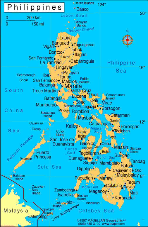
Map of
Philippines
President: Benigno "Noynoy" Aquino III (2010)
Land area: 115,124 sq mi (298,171 sq km);
total area: 115,830 sq mi (300,000 sq km)
Population (2014 est.): 107,668,231 (growth
rate: 1.81%); birth rate: 24.24/1000; infant mortality rate: 17.64/1000;
life expectancy: 72.48
Capital and largest city (2011 est.):
Manila, 11.862 million
Other large cities: Davao 1.565 million; Cebu City 855,000; Zamboanga 884,000 (2011)
Monetary unit:
Peso
National name: Republika ng
Pilipinas
Languages:
Filipino (based on Tagalog), English (both
official); eight major dialects: Tagalog, Cebuano, Ilocano, Hiligaynon
or Ilonggo, Bicol, Waray, Pampango, and Pangasinense
Ethnicity/race:
Tagalog 28.1%, Cebuano 13.1%, Ilocano 9%,
Bisaya/Binisaya 7.6%, Hiligaynon Ilonggo 7.5%, Bikol 6%, Waray 3.4%,
other 25.3% (2000)
Religions:
Roman Catholic 80.9%, Evangelical 2.8%, Iglesia ni
Kristo 2.3%, Aglipayan 2%, other Christian 5%, Islam 5% (2000)
Literacy rate: 95.4% (2008 est.)
Economic summary: GDP/PPP (2013 est.):
$454.3 billion; per capita $4,700. Real growth rate: 6.8%.
Inflation: 2.8%. Unemployment: 7.4%. Arable land:
18%. Agriculture: sugarcane, coconuts, rice, corn, bananas,
cassavas, pineapples, mangoes; pork, eggs, beef; fish. Labor force:
41.33 million; agriculture 32%, industry 15%, services 53% (2013 est.). Industries: electronics assembly, garments, footwear,
pharmaceuticals, chemicals, wood products, food processing, petroleum
refining, fishing. Natural resources: timber, petroleum,
nickel, cobalt, silver, gold, salt, copper. Exports: $47.45
billion (2013 est.): semiconductors and electronic products,
transport equipment, garments, copper products, petroleum products,
coconut oil, fruits. Imports: $63.91
billion (2013 est.): electronic products, mineral fuels,
machinery and transport equipment, iron and steel, textile fabrics,
grains, chemicals, plastic.
Major trading partners: Japan, U.S., Hong Kong,
China, Singapore, Malaysia, Saudi Arabia, Indonesia, South Korea, Thailand (2012).
Communications: Telephones: main lines in
use: 3.939 million (2012); mobile cellular: 103 million (2012).
Broadcast media:multiple national private TV
and radio networks; multi-channel satellite and cable TV systems
available; five national or major TV networks; one government-owned
network; 1100 cable TV providers and a government-operated national TV
and radio network; about 300 analog television stations; more than 1,000
radio stations; the Philippines is scheduled to complete the switch
from analog to digital broadcasting by the end of 2015 (2012). Internet Service
Providers (ISPs): 425,812 (2012). Internet users: 8.278 million (2009).
Transportation:
Railways: total: 995 km (2010). Highways: total: 213,151 km; paved: 54,481 km; unpaved: 158,670 km (2009). Waterways:
3,219 km; limited to shallow-draft (less than 1.5 m) vessels (2011). Ports
and harbors:Batangas, Cagayan de Oro, Cebu, Davao, Liman, Manila. Airports:247 (2013).
International disputes: Philippines
claims sovereignty over Scarborough Reef (also claimed by China
together with Taiwan) and over certain of the Spratly Islands, known
locally as the Kalayaan (Freedom) Islands, also claimed by China,
Malaysia, Taiwan, and Vietnam; the 2002 "Declaration on the Conduct of
Parties in the South China Sea," has eased tensions in the Spratly
Islands but falls short of a legally binding "code of conduct" desired
by several of the disputants; in March 2005, the national oil companies
of China, the Philippines, and Vietnam signed a joint accord to conduct
marine seismic activities in the Spratly Islands; Philippines retains a
dormant claim to Malaysia's Sabah State in northern Borneo based on
the Sultanate of Sulu's granting the Philippines Government power of
attorney to pursue a sovereignty claim on his behalf; maritime
delimitation negotiations continue with Palau.
-------------------- o --------------------
No comments:
Post a Comment