PORTUGAL
Geography: Portugal occupies the western part of the Iberian Peninsula and is slightly smaller than Indiana. The country is crossed by three large rivers that rise in Spain, flow into the Atlantic, and divide the country into three geographic areas. The Minho River, part of the northern boundary, cuts through a mountainous area that extends south to the vicinity of the Douro River. South of the Douro, the mountains slope to the plains around the Tejo River. The remaining division is the southern one of Alentejo. The Azores stretch over 340 mi (547 km) in the Atlantic and consist of nine islands with a total area of 902 sq mi (2,335 sq km). Madeira, consisting of two inhabited islands, Madeira and Porto Santo, and two groups of uninhabited islands, lie in the Atlantic about 535 mi (861 km) southwest of Lisbon.
Government: Parliamentary democracy.
History: An early Celtic tribe, the Lusitanians, are believed to have been the first inhabitants of Portugal. The Roman Empire conquered the region in about 140 BC Toward the end of the Roman Empire, the Visigoths had invaded the entire Iberian Peninsula.
Portugal won its independence from Moorish Spain in 1143. King John I (1385–1433) unified his country at the expense of the Castilians and the Moors of Morocco. The expansion of Portugal was brilliantly coordinated by John's son, Prince Henry the Navigator. In 1488, Bartolomeu Dias reached the Cape of Good Hope, proving that Asia was accessible by sea. In 1498, Vasco da Gama reached the west coast of India. By the middle of the 16th century, the Portuguese empire extended to West and East Africa, Brazil, Persia, Indochina, and the Malayan peninsula.
In 1581, Philip II of Spain invaded Portugal and held it for 60 years, precipitating a catastrophic decline in Portuguese commerce. Courageous and shrewd explorers, the Portuguese proved to be inefficient and corrupt colonizers. By the time the Portuguese monarchy was restored in 1640, Dutch, English, and French competitors had begun to seize the lion's share of the world's colonies and commerce. Portugal retained Angola and Mozambique in Africa, and Brazil (until 1822).
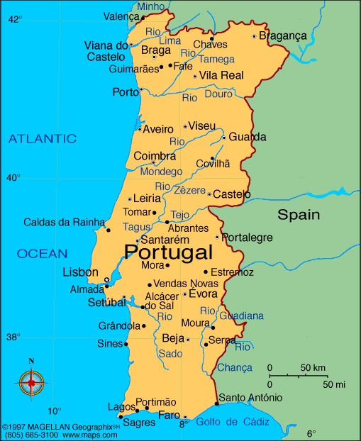
Map of Portugal
President: Aníbal Cavaco Silva
(2006)
Prime Minister: Pedro Passos Coelho (2011)
Land area: 35,382 sq mi (91,639 sq km);
total area: 35,672 sq mi (92,391 sq km)
Population (2014 est.): 10,813,834
(growth rate: 0.12%); birth rate: 9.42/1000; infant mortality rate:
4.48/1000; life expectancy: 79.01
Capital and largest city (2011 est.) Lisbon, 2.843 million
Other large city: Porto,
1.367 million (2011)
Monetary unit: Euro (formerly
escudo)
National name: República
Portuguesa
Languages:
Portuguese (official), Mirandese (official,
but locally used)
Ethnicity/race:
homogeneous Mediterranean stock; less than
100,000 citizens of black African descent who immigrated to mainland
during decolonization; East Europeans have entered since 1990
Religions:
Religion Roman Catholic 81%, other Christian
3.3%, other 0.6%, unknown 8.3%, none 6.8% (2011 census)
Literacy rate: 95.4% (2011 est.).
Economic summary: GDP/PPP (2013
est.): $243.3 billion; per capita $22,900. Real growth rate:
-1.8%. Inflation: 0.4%. Unemployment: 16.8%.
Arable land: 11.88%. Agriculture: grain, potatoes,
tomatoes, olives, grapes; sheep, cattle, goats, swine, poultry,
dairy products; fish. Labor force: 5.395 million (2013 est.);
services 59.8%, industry 28.5%, agriculture 11.7% (2009 est.).
Industries: textiles, clothing, footwear,
wood and cork, paper, chemicals, auto parts, base metals, porcelain and
ceramics, glassware, technology, telecommunications; dairy products,
wine, other foodstuffs; ship construction and refurbishment; tourism.
Natural resources: fish, forests (cork),
iron ore, copper, zinc, tin, tungsten, silver, gold, uranium, marble,
clay, gypsum, salt, arable land, hydropower. Exports: $61
billion (2013 est.): agricultural products, food products,
wine, oil products, chemical products, plastics and rubber, hides,
leather, wood and cork, wood pulp and paper, textile materials,
clothing, footwear, machinery and tools, base metals. Imports: $59
billion (2013 est.): agricultural products, chemical products,
vehicles and other transport material, optical and precision
instruments, computer accessories and parts, semi-conductors and related
devices, oil products, base metals, food products, textile materials. Major
trading partners: Spain, France, Germany, Angola, UK, Italy,
Netherlands (2012).
Communications: Telephones: main lines
in use: 4.558 million (2012); mobile cellular: 12.312 million
(2012). Radio broadcast stations: 300. Television broadcast stations: 40 (2008). Internet Service
Providers (ISPs): 3.748 million (2012). Internet users: 5.168 million
(2009).
Transportation: Railways: total: 3,319
km (2008). Highways: total: 82,900 km; paved: 71,294 km; unpaved: 11,606 km (2008).
Waterways: 210 km (on Douro River from Porto) (2011).
Ports and harbors: Leixoes, Lisbon, Setubal, Sines. Airports: 64
(2013).
International disputes: Portugal
does not recognize Spanish sovereignty over the territory of Olivenza
based on a difference of interpretation of the 1815 Congress of Vienna
and the 1801 Treaty of Badajoz.
-------------------- o --------------------
No comments:
Post a Comment