SAMOA
Geography: Samoa, formerly Western Samoa, is in the South Pacific Ocean about 2,200 mi (3,540 km) south of Hawaii. The larger islands in the Samoan chain, Upolu and Savai'i, are mountainous and of volcanic origin. There is little level land except in the coastal areas, where most cultivation takes place.
Government: Constitutional monarchy under a native chief.
History: Polynesians, possibly from Tonga, first settled in the Samoan islands about 1000 B.C. Samoa was explored by Dutch and French traders in the 18th century. Toward the end of the 19th century, conflicting interests of the U.S., Britain, and Germany resulted in an 1899 treaty that recognized the paramount interests of the U.S. in those islands west of 171°W (American Samoa) and Germany's interests in the other islands (Western Samoa).
New Zealand seized Western Samoa from Germany in 1914, and in 1946 it became a UN trust territory administered by New Zealand. A resistance movement to both German and New Zealand rule, known as the Mau (“strongly held view”) movement, helped to edge the islands toward independence on Jan. 1, 1962. A constitutional monarchy, Samoa has a legislative assembly whose members are from the matai, or titled class.
Barraged regularly by cyclones that have wreaked havoc on the country's primarily agrarian economy, Samoa has begun stepping up its tourism industry—not such a difficult undertaking in this archetypal South Pacific paradise.
A referendum in 1990 gave women the right to vote for the first time. In 1997, a new constitutional amendment changed the country's name to Samoa.
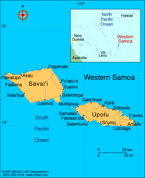
Map of Samoa
Independent State of Samoa
Head of State: Tuiatua Tupua Tamasese
Efi (since 20 June 2007)
Prime Minister: Tuilaepa Sailele
Malielegaoi (1998)
Land area: 1,100 sq mi (2,849 sq km);
total area: 1,137 sq mi (2,944 sq km)
Population (2014 est.): 196,628 (growth
rate: 0.59%); birth rate: 21.29/1000; infant mortality rate:
20.5/1000; life expectancy: 73.21; density per sq mi: 163.7
Capital and largest city (2011 est.):
Apia, 37,000
Monetary unit: Tala
Languages:
Samoan, English
Ethnicity/race:
Samoan 92.6%, Euronesians 7% (persons of
European and Polynesian blood), Europeans 0.4%
Religion:
Congregationalist 31.8%, Roman Catholic 19.4%,
Methodist 13.7%, Latter-Day Saints 15.2%, Assembly of God 8%,
Seventh-Day Adventist 3.9%, other Christian 5.5%, other 0.7%, unspecified 0.1% (2011)
National Holiday:
Flag Day, November 1
Literacy rate: 98.8% (2003 est.)
Economic summary: GDP/PPP $1.145
billion (2013 est.); per capita $6,200 (2013 est). Real growth
rate: 0.1% (2013 est). Inflation: 2.7% (2013).
Unemployment: n.a. Arable land: 2.82%. Agriculture:
coconuts, bananas, taro, yams, coffee, cocoa. Labor force:
47,930 (2011 est.). Industries: food processing, building
materials, auto parts. Natural resources: hardwood forests,
fish, hydropower. Exports: $11.4 million (2011): fish,
coconut oil and cream, copra, taro, automotive parts, garments,
beer. Imports: $318.7 million (2011): machinery and
equipment, industrial supplies, foodstuffs. Major trading
partners: American Samoa, Australia, U.S., New Zealand, Fiji,
Singapore, China (2012).
Communications: Telephones: main lines
in use: 35,300 (2010); mobile cellular: 167,400 (2010). Radio
broadcast stations: AM 2, FM 5, shortwave 0 (2004).
Radios: 174,849 (1997). Television broadcast stations:
4 (2009). Televisions: 8,634 (1999). Internet Service
Providers (ISPs): 18,013 (2012). Internet users: 9,000
(2009).
Transportation: Railways: 0 km.
Highways: total: 2,337 km; paved: 332 km; unpaved: 2,005 km
(2001 est.). Ports and harbors: Apia. Airports: 4 (2013).
International disputes: none.
-------------------- o --------------------
No comments:
Post a Comment