SÃO TOMÉ & PRÍNCIPE
Geography: The tiny volcanic islands of São Tomé and Príncipe lie in the Gulf of Guinea about 150 mi (240 km) off West Africa. São Tomé (about 330 sq mi; 859 sq km) is covered by a dense mountainous jungle, out of which have been carved large plantations. Príncipe (about 40 sq mi; 142 sq km) consists of jagged mountains. Other islands in the republic are Pedras Tinhosas and Rolas. About 95% of the population lives on São Tomé.
Government: Republic.
History: São Tomé and Príncipe, believed to have been originally uninhabited, were explored by Portuguese navigators in 1471 and settled by the end of the century. Intensive cultivation by slave labor made the islands a major producer of sugar during the 17th century, but output declined until the introduction of coffee and cocoa in the 19th century brought new prosperity. The island of São Tomé was the world's largest producer of cocoa in 1908, and the crop is still its most important. Working conditions for laborers, however, were horrendous, and in 1909 British and German chocolate manufacturers boycotted São Tomé cocoa in protest. An exile liberation movement was formed in 1953 after Portuguese landowners quelled labor riots by killing several hundred African workers.
The Portuguese revolution of 1974 brought the end of the overseas empire, and on July 12, 1975, Lisbon granted São Tomé independence. Manuel Pinto da Costa, leader of the only legal political party (Movement for the Liberation of São Tomé and Príncipe [MLSTP]), became president and Miguel Trovoada served as prime minister. After a 1978 coup attempt failed, Trovoada was accused of participating in the conspiracy and exiled. In 1990 a new constitution instituted multiparty rule. Trovoada returned and in March 1991 was voted president in the country's first free elections. Príncipe became autonomous in 1995.
Protests and unrest erupted throughout the 1990s over unemployment and soaring inflation. One of Africa's poorest countries, São Tomé has what are believed to be enormous untapped off-shore oil reserves—an estimated 6 billion barrels that are expected to begin flowing by 2007 or 2008. Businessman Fradique de Menezes won the presidential election in 2001. In July 2003, a military coup deposed Menezes while he was out of the country. International pressure resulted in Menezes's restoration to the presidency a week later. In 2006, Menezes won reelection with 60% of the vote, but the governing MDFM-PCD coalition did not win a majority of votes in parliamentary elections. In February 2008, the coalition agreed to a power-sharing deal with the opposition Independent Democratic Action (ADI) party. The party's leader, Patrice Trovoada, was appointed prime minister. He was named prime minister again in 2010, after his ADI won parliamentary elections, taking 26 of 55 seats. Trovoada would again lead a minority government until Dec. 2012 when Gabriel Costa took over as prime minster.
In the August 2011 presidential runoff, Manuel Pinto da Costa won 52.9% of the vote to secure the presidency, beating Evaristo Carvalho at 47.1%. Voter turnout was 74%. In Nov. 2014, Patrice Trovoada became prime minister for the third time.
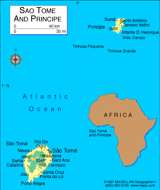
Map of São
Tomé and Príncipe
Democratic Republic of São Tomé and Príncipe
President: Manuel Pinto da Costa (2011)
Prime Minister:
Patrice Trovoada (2014)
Total area: 386 sq mi (1,001 sq km)
Population (2014 est.): 190,428 (growth
rate: 1.89%); birth rate: 35.12/1000; infant mortality rate: 49.16/1000;
life expectancy: 64.22
Capital and largest city (2011 est.):
São Tomé, 64,000
Monetary unit: dobra
National name: República Democrática de
São Tomé e Príncipe
Language:
Portuguese 98.4% (official), Forro 36.2%, Cabo Verdian
8.5%, French 6.8%, Angolar 6.6%, English 4.9%, Lunguie 1%, other
(including sign language) 2.4% (2012)
Ethnicity/race:
mestico (mixed European and native African),
angolares (descendants of Angolan slaves), forros (descendants of
freed slaves), servicais (contract laborers from Angola, Mozambique,
and Cape Verde), tongas (children of servicais born on the islands),
Europeans (primarily Portuguese), Asians (mostly Chinese)
Religions:
Catholic 55.7%, Adventist 4.1%, Assembly of God 3.4%, New Apostolic 2.8%,
Adventist 4.1%, other 6.2%, none 21.2%, unspecified 1% (2012)
Literacy rate: 69.5% (2008 census)
Economic summary: GDP/PPP (2013 est.):
$421 million; per capita $2,200 . Real growth rate: 4.5%.
Inflation: 8.7% (2013 est). Unemployment: n.a.
Arable land: 9.06%. Agriculture: cocoa, coconuts, palm
kernels, copra, cinnamon, pepper, coffee, bananas, papayas, beans;
poultry; fish. Labor force: 52,490 (2007); population mainly
engaged in subsistence agriculture and fishing; note: shortages of
skilled workers. Industries: light construction, textiles,
soap, beer, fish processing, timber. Natural resources: fish,
hydropower. Exports: $12.1 million (2013 est.): cocoa 80%,
copra, coffee, palm oil. Imports: $112.8 million (2013
est.): machinery and electrical equipment, food products, petroleum
products. Major trading partners: Netherlands, Belgium,
Spain, Portugal, U.S., Gabon, Nigeria (2012).
Communications: Telephones: main lines
in use: 8,000 (2012); mobile cellular: 122,000 (2012). Broadcast media:
1 government-owned TV station; 1 government-owned radio station; 3
independent local radio stations authorized in 2005 with 2 operating at
the end of 2006; transmissions of multiple international broadcasters
are available (2007). Internet Service Providers
(ISPs): 1,678 (2012). Internet users: 26,700 (2009).
Transportation: Railways: 0 km.
Highways: total: 320 km; paved: 218 km; unpaved: 102 km (2000
est.). Ports and harbors: Sao Tome. Airports:
2 (2013).
International disputes:
none.
-------------------- o --------------------
No comments:
Post a Comment