SENEGAL
Geography: The capital of Senegal, Dakar, is the westernmost point in Africa. The country, slightly smaller than South Dakota, surrounds Gambia on three sides and is bordered on the north by Mauritania, on the east by Mali, and on the south by Guinea and Guinea-Bissau.
Senegal is mainly a low-lying country, with a semidesert area in the north and northeast and forests in the southwest. The largest rivers include the Senegal in the north and the Casamance in the southern tropical climate region.
Government: Multiparty democractic republic.
History: The Toucouleur people, among the early inhabitants of Senegal, converted to Islam in the 11th century, although their religious beliefs retained strong elements of animism. The Portuguese had some stations on the banks of the Senegal River in the 15th century, and the first French settlement was made at St.-Louis in 1659. Gorée Island became a major center for the Atlantic slave trade through the 1700s, and millions of Africans were shipped from there to the New World. The British took parts of Senegal at various times, but the French gained possession in 1840 and made it part of French West Africa in 1895. In 1946, together with other parts of French West Africa, Senegal became an overseas territory of France. On June 20, 1960, it formed an independent republic federated with Mali, but the federation collapsed within four months.
Although Senegal is neither a large nor a strategically located country, it has nonetheless played a prominent role in African politics since its independence. As a black nation that is more than 90% Muslim, Senegal has been a diplomatic and cultural bridge between the Islamic and black African worlds. Senegal has also maintained closer economic, political, and cultural ties to France than probably any other former French African colony.
Senegal's first president, Léopold Sédar Senghor, towered over the country's political life until his voluntary retirement in 1981. He replaced multiparty democracy with an authoritarian regime. An acclaimed poet, Senghor sought to become a “black-skinned Frenchman,” a quest he ultimately discovered to be impossible. An advocate of “African socialism,” Senghor increased government involvement in the economy through a series of four-year plans.
In 1973 Senegal and six other nations created the West African Economic Community. When rising oil prices and fluctuations in the price of peanuts, a major export crop, ruined the economy in the 1970s, Senghor reversed course. He emphasized new industries such as tourism and fishing. Politically, the so-called passive revolution allowed limited opposition.
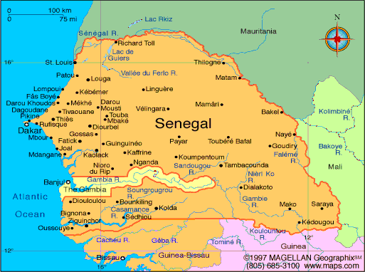
Map of Senegal
Republic of Senegal
President: Macky Sall (2012)
Prime Minister: Mohamed Dionne
(2014)
Land area: 74,131 sq mi (191,999 sq km);
total area: 75,749 sq mi (196,190 sq km)
Population (2014 est.): 13,635,927
(growth rate: 2.48%); birth rate: 35.09/1000; infant mortality rate:
52.72/1000; life expectancy: 60.95; density per sq mi: 169.1
Capital and largest city (2011 est.):
Dakar, 3.035 million
Monetary unit: CFA Franc
National name: République du
Sénegal
Languages:
French (official); Wolof, Pulaar, Jola,
Mandinka
Ethnicity/race:
Wolof 43.3%, Pular 23.8%, Serer 14.7%, Jola
3.7%, Mandinka 3%, Soninke 1.1%, European and Lebanese 1%, other
9.4%
Religions:
Islam 94%, Christian 5% (mostly Roman
Catholic), indigenous 1%
Literacy rate: 49.7% (2009 est.)
Economic summary: GDP/PPP (2013
est.): $27.72 billion; per capita $2,100. Real growth rate:
4%. Inflation: 0.8%. Unemployment: 48% (2007 est.).
Arable land: 19.57%.
Agriculture: peanuts, millet, corn, sorghum, rice, cotton,
tomatoes, green vegetables; cattle, poultry, pigs; fish. Labor
force: 6.096 million (2013 est.); agriculture 77.5%, industry and
services 22.5% (2007 est.). Industries:
agricultural and fish processing, phosphate mining, fertilizer
production, petroleum refining; iron ore, zircon, and gold mining,
construction materials, ship construction and repair.
Natural resources: fish, phosphates, iron ore.
Exports: $2.691 billion (2013 est.): fish, groundnuts
(peanuts), petroleum products, phosphates, cotton. Imports:
$5.61 billion (2013 est.): foods and beverages, capital
goods, fuels. Major trading partners: India, Mali, France,
Nigeria, UK, China, Switzerland, Guinea (2012).
Communications: Telephones: main lines
in use: 338,200 (2012); mobile cellular: 11.47 million (2012).
Radio broadcast stations: AM 8, FM 20, shortwave 1 (2007).
Radios: 1.24 million (1997). Television broadcast
stations: 1 (1997). Televisions: 361,000 (1997).
Internet Service Providers (ISPs): 237 (2012). Internet
users: 1.818 million (2009).
Transportation: Railways: total: 906 km
(2008). Highways: total: 14,008 km; paved: 4,099 km;
unpaved: 9,909 km (2003). Waterways: 1,000 km total; 785 km on
the Senegal river, and 112 km on the Saloum river. Ports and
harbors: Dakar, Kaolack, Matam, Podor, Richard Toll,
Saint-Louis, Ziguinchor. Airports: 20 (2013).
International disputes:
The Gambia and Guinea-Bissau attempt to stem separatist violence, cross
border raids, and arms smuggling into their countries from southern
Senegal's Casamance region.
-------------------- o --------------------
No comments:
Post a Comment