SEYCHELLES
Geography: The Seychelles consist of an archipelago of about 100 islands in the Indian Ocean northeast of Madagascar. The principal islands are Mahé (55 sq mi; 142 sq km), Praslin (15 sq mi; 38 sq km), and La Digue (4 sq mi; 10 sq km). The Aldabra, Farquhar, and Desroches groups are included in the territory of the republic.
Government: Socialist multiparty republic.
History: The Seychelles were uninhabited when the British East India Company arrived on the archipelago in 1609. Thereafter, they became a favorite pirate haven. The French claimed the islands in 1756 and administered them as part of the colony of Mauritius. The British gained control of the islands through the Treaty of Paris (1814) and changed the islands' name from the French Séchelles to the Anglicized Seychelles.
The islands became self-governing in 1975 and independent on June 29, 1976. They have remained a member of the Commonwealth of Nations. Their first president, James Mancham, was overthrown in 1977 by the prime minister, France-Albert René. At first René created a Socialist state with a one-party system, but later he reintroduced a multiparty system as well as various reforms.
To increase revenue, in 1996 the government quietly initiated an Economic Citizenship Program that provides foreigners with the opportunity to obtain a Seychelles passport upon payment of $25,000. A new law in late 1995 had granted immunity from criminal prosecution to anyone investing $10 million in the country.
In April 2004, President France-Albert René stepped down after 27 years in power. His vice president, James Michel, who had also served in the government for 27 years, assumed the presidency. In July 2006, Michel won reelection with 53.7% of the vote.
In presidential elections held May 19–21, 2011 incumbent James Michel (People's Party) won his third term with 55% of the vote against Wavel Ramkalawan's (Seychelles National Party) 41%. Voter turnout was 84% over a three-day period, which allowed for voters on outlying islands to participate.
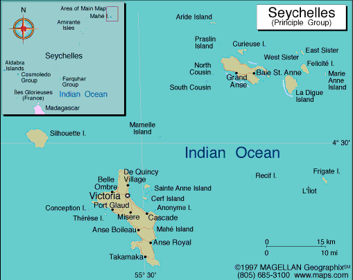
Map of
Seychelles
Republic of Seychelles
President: James Michel (2004)
Total area: 176 sq mi (456 sq km)
Population (2014 est.): 91,650 (growth
rate: .87%); birth rate: 14.54/1000; infant mortality rate:
10.77/1000; life expectancy: 74.25.
Capital and largest city (2011 est.):
Victoria, 27,000
Monetary unit: Seychelles rupee
Languages:
Seychellois Creole (official) 89.1%, English (official) 5.1%, French (official) 0.7%, other 3.8%, unspecified 1.4% (2010 est.)
Ethnicity/race:
mixed French, African, Indian, Chinese, and
Arab
Religions:
Roman Catholic 76.2%, Protestant 10.6% (Anglican 6.1%,
Pentecoastal Assembly 1.5%, Seventh-Day Adventist 1.2%, other Protestant
1.6), other Christian 2.4%, Hindu 2.4%, Muslim 1.6%, other
non-Christian 1.1%, unspecified 4.8%, none 0.9% (2010 est.)
Literacy rate: 91.8% (2011 est.)
Economic summary: GDP/PPP (2013
est.): $2.404 billion; per capita $25,900. Real growth rate:
3.3%. Inflation: 4.3%. Unemployment: 2% (2006 est.).
Arable land: 2.17%. Agriculture: coconuts, cinnamon,
vanilla, sweet potatoes, cassava (manioc, tapioca), copra, bananas; poultry; tuna.
Labor force: 39,560 (2006); industry 23%, services 74%,
agriculture 3% (2006). Industries: fishing, tourism,
processing of coconuts and vanilla, coir (coconut fiber) rope, boat
building, printing, furniture; beverages. Natural resources:
fish, copra, cinnamon trees. Exports: $516.7 million (2013 est.): canned tuna, frozen fish, cinnamon bark, copra,
petroleum products (reexports). Imports: $846.4 million
(2013 est.): machinery and equipment, foodstuffs, petroleum
products, chemicals, other manufactured goods. Major trading partners: UK, France,
Italy, Japan, Spain, Saudi Arabia (2012).
Member of Commonwealth of Nations
Communications: Telephones: main lines
in use: 28,900 (2012); mobile cellular: 138,300 (2012). Radio
broadcast stations: AM 1, FM 1 (2007).Television broadcast stations: 1. Internet Service Providers (ISPs): 247 (2012). Internet
users: 32,000 (2008).
Transportation: Railways: 0 km.
Highways: total: 508 km; paved: 490 km; unpaved: 18 km
(2010). Ports and harbors: Victoria. Airports: 14 (2013).
International disputes: claims the
Chagos Archipelago (UK-administered British Indian Ocean
Territory).
-------------------- o --------------------
No comments:
Post a Comment