SIERRA LEONE
Geography: Sierra Leone, on the Atlantic Ocean in West Africa, is half the size of Illinois. Guinea, in the north and east, and Liberia, in the south, are its neighbors. Mangrove swamps lie along the coast, with wooded hills and a plateau in the interior. The eastern region is mountainous.
Government: Constitutional democracy.
History: The Bulom people were thought to have been the earliest inhabitants of Sierra Leone, followed by the Mende and Temne peoples in the 15th century and thereafter the Fulani. The Portuguese were the first Europeans to explore the land and gave Sierra Leone its name, which means “lion mountains.” Freetown, on the coast, was ceded to English settlers in 1787 as a home for blacks discharged from the British armed forces and also for runaway slaves who had found asylum in London. In 1808 the coastal area became a British colony, and in 1896 a British protectorate was proclaimed over the hinterland.
Sierra Leone became an independent nation on April 27, 1961. A military coup overthrew the civilian government in 1967, which was in turn replaced by civilian rule a year later. The country declared itself a republic on April 19, 1971.
A coup attempt early in 1971 led to then prime minister Siaka Stevens calling in troops from neighboring Guinea's army, which remained for two years. Stevens turned the government into a one-party state under the aegis of the All People's Congress Party in April 1978. In 1992 rebel soldiers overthrew Stevens's successor, Joseph Momoh, calling for a return to a multiparty system. In 1996, another military coup ousted the country's military leader and president. Nevertheless, a multiparty presidential election proceeded in 1996, and People's Party candidate Ahmad Tejan Kabbah won with 59.4% of the vote, becoming Sierra Leone's first democratically elected president.
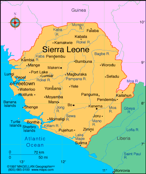
Map of Sierra
Leone
President: Ernest Koroma (2007)
Land area: 27,653 sq mi (71,621 sq km);
total area: 27,699 sq mi (71,740 sq km)
Population (2014 est.): 5,743,725
(growth rate: 2.33%); birth rate: 37.4/1000; infant mortality rate:
73.29/1000; life expectancy: 57.39; density per sq mi: 205.6
Capital and largest city (2011 est.):
Freetown, 941,000
Monetary unit: Leone
Languages:
English (official), Mende (southern
vernacular), Temne (northern vernacular), Krio (lingua franca)
Ethnicity/race:
Temne 35%, Mende 31%, Limba 8%, Kono 5%, Kriole 2%
(descendants of freed Jamaican slaves who were settled in the Freetown
area in the late-18th century; also known as Krio), Mandingo 2%, Loko
2%, other 15% (includes refugees from Liberia's recent civil war, and
small numbers of Europeans, Lebanese, Pakistanis, and Indians) (2008
census)
Religions:
Islam 60%, indigenous 30%, Christian 10%
Literacy rate: 43.3% (2011 est.)
Economic summary: GDP/PPP (2013
est.): $9.156 billion; per capita $1,400. Real growth rate:
13.3%. Inflation: 11.1%. Unemployment: n.a. Arable
land: 15.33%. Agriculture: rice, coffee, cocoa, palm kernels,
palm oil, peanuts; poultry, cattle, sheep, pigs; fish. Labor
force: 2.207 million (2007 est.). Industries: diamond
mining; iron ore, rutile and bauxite mining; small-scale manufacturing
(beverages, textiles, cigarettes, footwear); petroleum refining, small
commercial ship repair.
Natural resources: diamonds, titanium ore, bauxite, iron ore,
gold, chromite. Exports: $1.563 billion (2013):
diamonds, rutile, cocoa, coffee, fish. Imports: $1.637 billion
(2013): foodstuffs, machinery and equipment, fuels and
lubricants, chemicals. Major trading partners: Belgium,
U.S., UK, China, Japan, Turkey, South Africa, India (2012).
Member of Commonwealth of Nations
Communications: Telephones: main lines
in use: 18,000 (2012); mobile cellular: 2.21 million (2012). Radio
broadcast stations: AM 1, FM 9, shortwave 1 (2001). Radios:
1.12 million (1997). Television broadcast stations: 2
(2007). Televisions: 53,000 (1997). Internet Service
Providers (ISPs): 282 (2012). Internet users: 14,900
(2009).
Transportation: Railways: total: 84 km
used on a limited basis because the mine at Marampa is closed
(2001). Highways: total: 11,330 km; paved: 904 km; unpaved:
10,396 km (2002). Waterways: 800 km; 600 km navigable year
round. Ports and harbors: Freetown, Pepel, Sherbo Islands
Airports: 8 (2013).
International disputes:
Sierra Leone opposes Guinean troops' continued occupation of Yenga, a
small village on the Makona River that serves as a border with Guinea;
Guinea's forces came to Yenga in the mid-1990s to help the Sierra
Leonean military to suppress rebels and to secure their common border
but have remained there even after both countries signed a 2005
agreement acknowledging that Yenga belonged to Sierra Leone; in 2012,
the two sides signed a declaration to demilitarize the area.
-------------------- o --------------------
No comments:
Post a Comment