SLOVAKIA
Geography: Slovakia is located in central Europe. The land has rugged mountains, rich in mineral resources, with vast forests and pastures. The Carpathian Mountains dominate the topography of Slovakia, with lowland areas in the southern region. Slovakia is about twice the size of the state of Maryland.
Government: Parliamentary democracy.
History: Present-day Slovakia was settled by Slavic Slovaks about the 6th century. They were politically united in the Moravian empire in the 9th century. In 907, the Germans and the Magyars conquered the Moravian state, and the Slovaks fell under Hungarian control from the 10th century up until 1918. When the Hapsburg-ruled empire collapsed in 1918 following World War I, the Slovaks joined the Czech lands of Bohemia, Moravia, and part of Silesia to form the new joint state of Czechoslovakia. In March 1939, Germany occupied Czechoslovakia, established a German “protectorate,” and created a puppet state out of Slovakia with Monsignor Josef Tiso as prime minister. The country was liberated from the Germans by the Soviet army in the spring of 1945, and Slovakia was restored to its prewar status and rejoined to a new Czechoslovakian state.
After the Communist Party took power in Feb. 1948, Slovakia was again subjected to a centralized Czech-dominated government, and antagonism between the two republics developed. In Jan. 1969, the nation became the Slovak Socialist Republic of Czechoslovakia.
Nearly 42 years of Communist rule for Slovakia ended when Vaclav Havel became president of Czechoslovakia in 1989 and democratic political reform began. However, with the demise of Communist power, a strong Slovak nationalist movement resurfaced, and the rival relationship between the two states increased. By the end of 1991, discussions between Slovak and Czech political leaders turned to whether the Czech and Slovak republics should continue to coexist within the federal structure or be divided into two independent states.
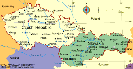
Map of Slovakia
President: Andrej Kiska (2014)
Prime Minister: Robert Fico
(2012)
Land area: 18,842 sq mi (48,800 sq km);
total area: 18,859 sq mi (48,845 sq km)
Population (2014 est.): 5,443,583 (growth
rate: 0.03%); birth rate: 10.01/1000; infant mortality rate: 5.35/1000;
life expectancy: 76.69; density per sq mi: 287
Capital and largest city (2011 est.):
Bratislava, 434,000
Other large city: Kosice, 240,688
Monetary unit: Koruna
National
name: Slovenska Republika
Languages:
Slovak 78.6% (official), Hungarian 9.4%, Roma 2.3%,
Ruthenian 1%, other or unspecified 8.8% (2011)
Ethnicity/race:
Slovak 80.7%, Hungarian 8.5%, Roma 2%,
other and unspecified 8.8% (2011)
Religions:
Roman Catholic 62%, Protestant 8.2%, Greek
Catholic 3.8%, none 13.4%, other or unspecified 12.5% (2011)
Literacy
rate: 99.6% (2004 est.)
Economic
summary: GDP/PPP (2013 est.): $133.4 billion; per capita
$24,700. Real growth rate: 0.8%. Inflation: 1.7%.
Unemployment: 14.4% (2013 est.). Arable land: 28.36%.
Agriculture: grains, potatoes, sugar beets, hops, fruit; pigs,
cattle, poultry; forest products. Labor force: 2.727 million
(2013 est.); agriculture 3.1%, industry 30.8%, services 47% (2013).
Industries: metal and metal
products; food and beverages; electricity, gas, coke, oil, nuclear
fuel; chemicals, synthetic fibers; machinery; paper and printing;
earthenware and ceramics; transport vehicles; textiles; electrical and
optical apparatus; rubber products. Natural resources: brown
coal and lignite; small amounts of iron ore, copper and manganese ore;
salt; arable land. Exports: $82.7 billion (2013 est.):
vehicles 21%, machinery and electrical equipment 35.9%, base metals
11.3%, chemicals and minerals 8.1%, plastics 4.9% (2009). Imports:
$77.96 billion (2013 est.): machinery and transport
equipment 31%, mineral products 13%, vehicles 12%, base metals 9%, chemicals 8%, plastics 6% (2009).
Major trading partners: Germany, Czech Republic, Austria,
Italy, Poland, Hungary, Russia, France, U.K., South Korea (2012).
Communications: Telephones: main lines in
use: 975,000 (2012); mobile cellular: 6.095 million (2012). Radio
broadcast stations: AM 15, FM 78, shortwave 2 (2008).
Radios: 3.12 million (1997). Television broadcast stations:
38 (plus 864 repeaters) (1995). Televisions: 2.62 million
(2008). Internet Service Providers (ISPs): 1.384 million (2012).
Internet users: 4.063 million (2009).
Transportation: Railways: total: 3,622 km
(2008). Highways: total: 43,916 km; paved: 38,238 km (including
417 km of expressways); unpaved: 5,678 km (2010). Waterways:
172 km on the Danube. Ports and harbors: Bratislava,
Komarno. Airports: 35 (2013).
International disputes:
bilateral government, legal, technical and economic working group
negotiations continued in 2006 between Slovakia and Hungary over
Hungary's completion of its portion of the Gabcikovo-Nagymaros
hydroelectric dam project along the Danube; as a member state that forms
part of the EU's external border, Slovakia has implemented the strict
Schengen border rules.
-------------------- o --------------------
No comments:
Post a Comment