SOLOMON ISLANDS
Geography: A scattered archipelago of about 1,000 mountainous islands and low-lying coral atolls, the Solomon Islands lie east of Papua New Guinea and northeast of Australia in the south Pacific. The islands include Guadalcanal, Malaita, Santa Isabel, San Cristóbal, Choiseul, New Georgia, and the Santa Cruz group.
Government: Parliamentary democracy.
History: It is thought that people have lived in the Solomon Islands since at least 2000 B.C. Explored in 1568 by Alvaro de Mendana of Spain, the Solomons were not visited again for about 200 years. In 1886, Great Britain and Germany divided the islands between them, but later Britain was given control of the entire territory. The Japanese invaded the islands in World War II, and they were the scene of some of the bloodiest battles in the Pacific theater, most famously the battle of Guadalcanal. The British gained control of the island again in 1945. In 1976 the islands became self-governing and gained independence in 1978.
The border with Papua New Guinea (PNG) remained a source of tension in the 1990s. Incursions into Solomon Islands territory by PNG forces, who were countering secessionist action on neighboring Bougainville Island, gave rise to formal protests in mid-1997.
Since early 1999, the Isatabu Freedom Movement, a militia group made up of indigenous Isatabus from Guadalcanal, have expelled more than 20,000 Malaitans from the island. The Malaitans had migrated from nearby Malaita, and many secured jobs in the capital, Honiara, stirring resentment among Isatabus that has grown steadily since independence. In response to the ethnic violence and expulsions, a rival Malaitan militia group was founded, the Malaita Eagle Force. In June 2000, the Malaita Eagle Force stole police weapons, forced Prime Minister Bartholomew Ulufa'alu to resign, and seized control of Honiara. The rival groups agreed to a cease-fire in June 2000, barely averting a civil war. Although a peace agreement had been signed and elections had taken place, the country continued to suffer from lawlessness. In July 2003, at the request of the prime minister, a 2,250-strong international peacekeeping force led by Australia arrived on the island to restore order, disarm the militias, and expel the “thieves, drunkards, and extortionists” from the notoriously corrupt police force. Australia's intervention was highly successful, and two years after troops had arrived, the country remained relatively stable.
In April 2006 Snyder Rini was appointed prime minister. Rioting and looting followed—many claimed Rini, who had previously served as deputy prime minister, was beholden to Chinese interests. Eight days later he stepped down. The parliament then elected the opposition candidate, Manasseh Sogavare, to the post.
A magnitude 8.0 earthquake and tsunami struck the Solomon Islands in April 2007, killing at least 20 people and destroying villages.
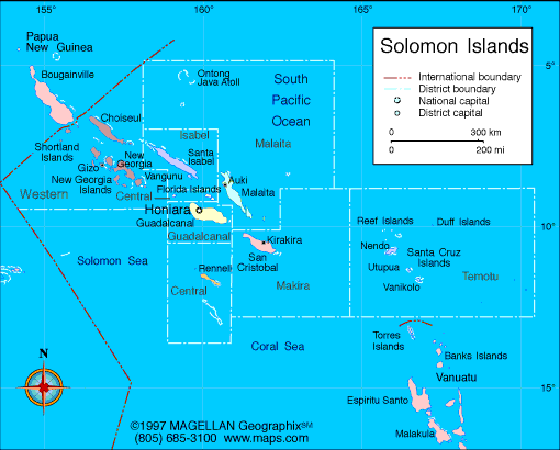
Map of
Solomon Islands
Sovereign: Queen Elizabeth II
(1952)
Governor-General: Frank Kabui
(2009)
Prime Minister: Manasseh Sogavare
(2014)
Land area: 10,633 sq mi (27,539 sq km);
total area: 10,985 sq mi (28,450 sq km)
Population (2014 est.): 609,883 (growth
rate: 2.07%); birth rate: 26.33/1000; infant mortality rate:
16.17/1000; life expectancy: 74.89; density per sq mi: 46.9
Capital and largest city (2011 est.):
Honiara (on Guadalcanal), 68,000
Monetary unit: Solomon Islands
dollar
Languages:
English 1%–2% (official), Melanesian pidgin
(lingua franca), 120 indigenous languages
Ethnicity/race:
Melanesian 95.3%, Polynesian 3.1%, Micronesian
1.2%, other 0.3% (2009 est.)
Religions:
Protestant 73.4% (Church of Melanesia 31.9%, South Sea
Evangelical 17.1%, Seventh Day Adventist 11.7%, United Church 10.1%,
Christian Fellowship Church 2.5%), Roman Catholic 19.6%, other Christian
2.9%, other 4%, none 0.03%, unspecified 0.1% (2009 est.)
Literacy rate: 84.1%
Economic summary: GDP/PPP (2013
est.): $1.958 billion; per capita $3,400. Real growth rate:
4%. Inflation: 2.6%. Unemployment: n.a.
Arable land: 0.62%. Agriculture: cocoa, coconuts,
palm kernels, rice, fruit; timber; cattle,
pigs; fish. Labor force: 202,500 (2007); agriculture 75%,
industry 5%, services 20% (2000 est.). Industries: fish,
timber, mining. Natural resources: fish, forests,
gold, bauxite, phosphates, lead, zinc, nickel. Exports: $493.1
million (2011 est.): timber, fish, copra, palm oil, cocoa.
Imports: $446 million (2012): food, plant and
equipment, manufactured goods, fuels, chemicals. Major trading
partners: China, New Zealand, Malaysia,
Australia, Singapore
(2012).
Member of British Commonwealth
Communications: Telephones: main lines
in use: 8,060 (2012); mobile cellular: 302,100 (2012). Radio
broadcast stations: AM 2, FM 2, shortwave 2 (2009). Radios:
57,000 (1997). Television broadcast stations: 1 (2009).
Televisions: 3,000 (1997). Internet Service Providers
(ISPs): 4,370 (2012). Internet users: 10,000 (2009).
Transportation: Railways: 0 km.
Highways: total: 1,390 km; paved: 34 km; unpaved: 1,356 km
(2011 est.). Ports and harbors: Honiara, Malloco Bay,
Viru Harbor, Tulaghi. Airports: 36 (2013).
International disputes:
since 2003, the Regional Assistance Mission to Solomon Islands,
consisting of police, military, and civilian advisors drawn from 15
countries, has assisted in reestablishing and maintaining civil and
political order while reinforcing regional stability and security.
-------------------- o --------------------
No comments:
Post a Comment