SOMALIA
Geography: Somalia, situated in the Horn of Africa, lies along the Gulf of Aden and the Indian Ocean. It is bounded by Djibouti in the northwest, Ethiopia in the west, and Kenya in the southwest. In area it is slightly smaller than Texas. Generally arid and barren, Somalia has two chief rivers, the Shebelle and the Juba.
Government: Between Jan. 1991 and Aug. 2000, Somalia had no working government. A fragile parliamentary government was formed in 2000, but it expired in 2003 without establishing control of the country. In 2004, a new transitional parliament was instituted and elected a president.
History: From the 7th to the 10th century, Arab and Persian trading posts were established along the coast of present-day Somalia. Nomadic tribes occupied the interior, occasionally pushing into Ethiopian territory. In the 16th century, Turkish rule extended to the northern coast, and the sultans of Zanzibar gained control in the south.
After British occupation of Aden in 1839, the Somali coast became its source of food. The French established a coal-mining station in 1862 at the site of Djibouti, and the Italians planted a settlement in Eritrea. Egypt, which for a time claimed Turkish rights in the area, was succeeded by Britain. By 1920, a British and an Italian protectorate occupied what is now Somalia. The British ruled the entire area after 1941, with Italy returning in 1950 to serve as United Nations trustee for its former territory.
By 1960, Britain and Italy granted independence to their respective sectors, enabling the two to join as the Republic of Somalia on July 1, 1960. Somalia broke diplomatic relations with Britain in 1963 when the British granted the Somali-populated Northern Frontier District of Kenya to the Republic of Kenya.
On Oct. 15, 1969, President Abdi Rashid Ali Shermarke was assassinated and the army seized power. Maj. Gen. Mohamed Siad Barre, as president of a renamed Somali Democratic Republic, leaned heavily toward the USSR. In 1977, Somalia openly backed rebels in the easternmost area of Ethiopia, the Ogaden Desert, which had been seized by Ethiopia at the turn of the century. Somalia acknowledged defeat in an eight-month war against the Ethiopians that year, having lost much of its 32,000-man army and most of its tanks and planes. President Siad Barre fled the country in late Jan. 1991. His departure left Somalia in the hands of a number of clan-based guerrilla groups, none of which trusted each other.
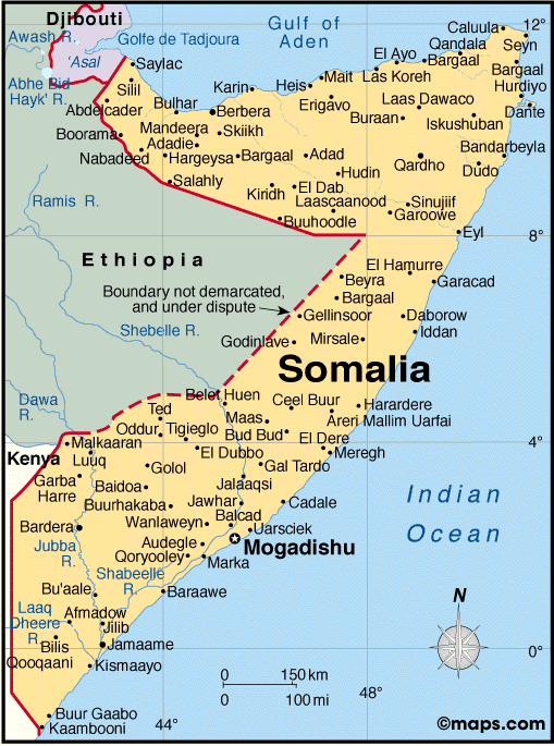
Map of Somalia
President: Hassan Sheikh Mohamud (2012)
Prime Minister: Abdi Farrah Shirdon Said (2012)
Land area: 242,216 sq mi (627,339 sq km);
total area: 246,199 sq mi (637,657 sq km)
Population (July 2014 est.): 10,428,043
(growth rate: 1.75%); birth rate: 40.87/1000; infant mortality rate:
100.14/1000; life expectancy: 51.58
Capital and largest city (2011 est.):
Mogadishu, 1.554 million
Monetary unit: Somali
shilling
National name: Soomaaliya
Languages:
Somali (official), Arabic, English,
Italian
Ethnicity/race:
Somali 85%, Bantu and others 15% (including
Arabs 30,000)
Religion:
Islam (Sunni)
Literacy rate: 37.8% (2001 est.)
Economic summary: GDP/PPP (2010
est.): $5.896 billion; per capita $600. Real growth rate:
2.6%. Inflation: n.a. (businesses print their own money).
Unemployment: n.a. Arable land: 1.73%.
Agriculture: bananas, sorghum, corn, coconuts, rice,
sugarcane, mangoes, sesame seeds, beans; cattle, sheep, goats; fish.
Labor force: 3.447 million (very few are skilled laborers);
agriculture (mostly pastoral nomadism) 71%, industry and services
29%. Industries: a few light industries, including sugar
refining, textiles, wireless communication. Natural resources:
uranium and largely unexploited reserves of iron ore, tin,
gypsum, bauxite, copper, salt, natural gas, likely oil reserves.
Exports: $515.8 million (2012 est.): livestock, bananas,
hides, fish, charcoal, scrap metal. Imports: $1.263 billion
(2010 est.): manufactures, petroleum products, foodstuffs,
construction materials, qat. Major trading partners: UAE,
Yemen, Oman, Djibouti, Kenya, India, China, Pakistan (2012).
Communications: Telephones: main lines
in use: 100,000 (2012); mobile cellular: 658,000 (2012). Broadcast media: 2
private TV stations rebroadcast Al-Jazeera and CNN; Somaliland has 1
government-operated TV station and Puntland has 1 private TV station;
Radio Mogadishu operated by the transitional government; 1 SW and
roughly 10 private FM radio stations broadcast in Mogadishu; several
radio stations operate in central and southern regions; Somaliland has 1
government-operated radio station; Puntland has roughly a half dozen
private radio stations; transmissions of at least 2 international
broadcasters are available (2007). Internet Service Providers (ISPs): 186 (2012). Internet users:
106,000 (2009).
Transportation: Railways: 0 km.
Highways: total: 22,100 km; paved: 2,608 km; unpaved: 19,492
km (2000 est.). Ports and harbors: Berbera, Kismaayo. Airports: 61
(2013).
International disputes:
Ethiopian forces invaded southern Somalia and routed Islamist Courts
from Mogadishu in January 2007; "Somaliland" secessionists provide port
facilities in Berbera to landlocked Ethiopia and have established
commercial ties with other regional states; "Puntland" and "Somaliland"
"governments" seek international support in their secessionist
aspirations and overlapping border claims; the undemarcated former
British administrative line has little meaning as a political separation
to rival clans within Ethiopia's Ogaden and southern Somalia's Oromo
region; Kenya works hard to prevent the clan and militia fighting in
Somalia from spreading south across the border, which has long been
open to nomadic pastoralists.
-------------------- o --------------------
No comments:
Post a Comment