SOUTH AFRICA
Geography: South Africa, on the continent's southern tip, is bordered by the Atlantic Ocean on the west and by the Indian Ocean on the south and east. Its neighbors are Namibia in the northwest, Zimbabwe and Botswana in the north, and Mozambique and Swaziland in the northeast. The kingdom of Lesotho forms an enclave within the southeast part of South Africa, which occupies an area nearly three times that of California.
The southernmost point of Africa is Cape Agulhas, located in the Western Cape Province about 100 mi (161 km) southeast of the Cape of Good Hope.
Government: Republic.
History: The San people were the first settlers; the Khoikhoi and Bantu-speaking tribes followed. The Dutch East India Company landed the first European settlers on the Cape of Good Hope in 1652, launching a colony that by the end of the 18th century numbered only about 15,000. Known as Boers or Afrikaners, and speaking a Dutch dialect known as Afrikaans, the settlers as early as 1795 tried to establish an independent republic.
After occupying the Cape Colony in that year, Britain took permanent possession in 1815 at the end of the Napoleonic Wars, bringing in 5,000 settlers. Anglicization of government and the freeing of slaves in 1833 drove about 12,000 Afrikaners to make the “great trek” north and east into African tribal territory, where they established the republics of the Transvaal and the Orange Free State.
The discovery of diamonds in 1867 and gold nine years later brought an influx of “outlanders” into the republics and spurred Cape Colony prime minister Cecil Rhodes to plot annexation. Rhodes's scheme of sparking an “outlander” rebellion, to which an armed party under Leander Starr Jameson would ride to the rescue, misfired in 1895, forcing Rhodes to resign. What British expansionists called the “inevitable” war with the Boers broke out on Oct. 11, 1899. The defeat of the Boers in 1902 led in 1910 to the Union of South Africa, composed of four provinces, the two former republics, and the old Cape and Natal colonies. Louis Botha, a Boer, became the first prime minister. Organized political activity among Africans started with the establishment of the African National Congress in 1912.
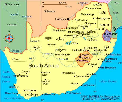
Map of South
Africa
President: Jacob Zuma (2009)
Total area: 471,008 sq mi (1,219,912 sq
km)
Population (2014 est.): 48,375,645
(growth rate: –0.48%); birth rate: 18.94/1000; infant mortality
rate: 41.61/1000; life expectancy: 49.56; density per sq mi: 109.8
Administrative capital (2011 est.):
Pretoria, 1.501 million; Legislative capital and largest city: Cape
Town, 3.562 million. Judicial
capital: Bloemfontein, 468,000. No decision has been made to
relocate the seat of government. South Africa is demarcated into
nine provinces, consisting of the Gauteng, Northern Province,
Mpumalanga, North West, KwaZulu/Natal, Eastern Cape, Western Cape,
Northern Cape, and Free State. Each province has its own capital.
Other large cities:
Johannesburg, 3.844 million; Ekurhuleni, 3.357 million; Durban, 3.012 million (2011).
Monetary unit: Rand
Languages:
IsiZulu 22.7%, IsiXhosa 16%, Afrikaans
13.5%, Sepedi 9.1%, English 9.6%, Setswana 8%, Sesotho 7.6%,
Xitsonga 4.5%, siSwati 2.5%, Tshivenda 2.4%, isiNdebele 2.1%, other 1.6% (2011)
Ethnicity/race:
black African 79.2%, white 8.9%, colored 8.9%,
Indian/Asian 2.5%, other 0.5% (2011)
Religions:
Zionist Christian 11.1%, Pentecostal/Charismatic 8.2%,
Methodist 6.8%, Dutch Reformed 6.7%, Anglican 3.8%, Catholic 7.1%,
Muslim 1.5%, other Christian 36%, other 2.3%, unspecified 1.4%, none
15.1% (2001)
Literacy rate: 93% (2011 est.)
Economic summary: GDP/PPP (2013
est.): $595.7 billion; per capita $11,500. Real growth rate:
2%. Inflation: 5.8%. Unemployment: 24.9%. Arable
land: 9.87%. Agriculture: corn, wheat, sugarcane, fruits,
vegetables; beef, poultry, mutton, wool, dairy products. Labor
force: 18.54 million (2013 est.); agriculture 9%,
industry 26%, services 65% (2007 est.). Industries: mining
(world's largest producer of platinum, gold, chromium), automobile
assembly, metalworking, machinery, textiles, iron and steel,
chemicals, fertilizer, foodstuffs, commercial ship repair.
Natural resources: gold, chromium, antimony,
coal, iron ore, manganese, nickel, phosphates, tin, rare earth
elements, uranium, gem diamonds, platinum, copper, vanadium, salt,
natural gas. Exports: $91.05 billion
(2013 est.): gold, diamonds, platinum, other metals and
minerals, machinery and equipment. Imports: $99.55 billion
(2013 est.): machinery and equipment, chemicals, petroleum
products, scientific instruments, foodstuffs. Major trading
partners: U.S., Japan, Germany, China, India,
Saudi Arabia (2012).
Communications: Telephones: main lines
in use: 4.03 million (2012); mobile cellular: 68.4 million
(2012). Radio broadcast stations: AM 14, FM 347 (plus 243
repeaters), shortwave 1 (2007). Radios: 17 million (2001).
Television broadcast stations: 556 (plus 144 network
repeaters) (1997). Televisions: 6 million (2000). Internet
Service Providers (ISPs): 4.761 million (2012). Internet users:
4.42 million (2009).
Transportation: Railways: total: 20,192
km (2008). Highways: total: 364,131 km; paved: 62,995 km
(including 254 km of expressways); unpaved: 301,136 km (2002).
Ports and harbors: Cape Town, Durban, Port Elizabeth, Richards Bay, Saldanha Bay.
Airports: 566
(2013).
International disputes: South
Africa has placed military units to assist police operations along the
border of Lesotho, Zimbabwe, and Mozambique to control smuggling,
poaching, and illegal migration; the governments of South Africa and
Namibia have not signed or ratified the text of the 1994 Surveyor's
General agreement placing the boundary in the middle of the Orange
River.
-------------------- o --------------------
No comments:
Post a Comment