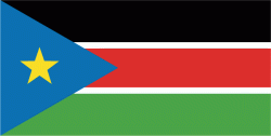
SOUTH SUDAN
Geography: South Sudan is a landlocked country in eastern Africa with plains in the north and center and highlands in the south, along the border with Uganda and Kenya. The White Nile, a tributary of the Nile, flows north through the country. It's the major geographic feature of the country and supports agriculture and large wild animal populations. South Sudan is bordered by Central African Republic, Democratic Republic of the Congo, Ethiopia, Kenya, Sudan, and Uganda.
Government: Republic. South Sudan gained independence from Sudan on July 9, 2011
History: The Egyptians conquered Sudan in 1874 and established the province of Equatoria. Islamic Mahdist revolutionaries entered the territory in 1885, but British troops defeated the invaders and took over Sudan in 1898. (Britain had occupied Egypt since 1882.) Britain and Egypt ruled the country in conjunction as Anglo-Egyptian Sudan. In the early 20th century, Christian missionaries converted a large segment of the population and introduced English to the region. The result was a clearly defined line between the Arab north and the black African animists and Christians in the south.
Egypt and Britain ruled Sudan until 1953, when Anglo-Egyptian Sudan was granted Sudan self-government. In 1955, army officers in the south mutinied, sparking a civil war between the north and south. Southerners accused the government, based in the north, of trying to force Islamic and Arab culture on the south. In addition, the south said the government reneged on promises to grant the south more autonomy through a federal system of government. Independence was proclaimed on Jan. 1, 1956, and the civil war dragged on until the 1972 signing of the Addis Ababa Agreement. About 500,000 people died in the war. Under the accord, the Southern Sudan Autonomous Region was formed.
War broke out again in 1983 when President Gaafar Mohamed Nimeiri abrogated the treaty and declared all of Sudan a Muslim state, ruled by shariah, or Islamic law. In response, southern rebels formed the Sudan People's Liberation Army (SPLA) and fought the government for more than two decades. Government troops unleashed vicious massacres against civilians and entire villages. The government also provoked internecine violence between tribes and ethnic groups. A cease-fire was declared between the Sudanese government and the SPLA in July 2002. During peace talks, the government agreed to a power-sharing government for six years, to be followed by a referendum on self-determination for the south. Fighting on both sides continued throughout the peace negotiations.
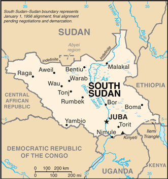
Map of South Sudan
President: Salva Kiir Mayardiit (2005)
Total area: 400,367 sq mi
(644,329 sq km)
Population: 11,562,695 (2014 est.); infant mortality rate:
68.16/1000 (2014 est.).
Capital and largest city: Juba, 269,000 (2011 est.).
Monetary
unit: Dinar (South Sudan's central bank has said it will introduce a new currency, the South Sudanese Pound)
National name:
Republic of South Sudan
Languages:
English (official), Arabic (includes Juba and Sudanese
variants), regional languages include Dinka, Nuer, Bari, Zande, Shilluk
Ethnicity/race:
Dinka 35.8%, Nuer 15.6%, Shilluk, Azande, Bari, Kakwa, Kuku,
Murle, Mandari, Didinga, Ndogo, Bviri, Lndi, Anuak, Bongo, Lango,
Dungotona, Acholi (2011 est.)
Religion:
animist, Christian
Literacy rate: 27% (2009 est.).
Economic summary: GDP/PPP (2013 est.):
$14.71 billion; per capita $1,400. Real growth rate: 24.7%.
Inflation: 1.7%. Unemployment: NA.
Arable land: NA. Agriculture:
hydropower, fertile agricultural land, gold, diamonds, petroleum,
hardwoods, limestone, iron ore, copper, chromium ore, zinc, tungsten,
mica, silver. Labor force: NA.
Communications: Telephones: main lines in
use: 2,200 (2012); mobile cellular: 2 million (2012).
Transportation: Railways: 248 km (2014).
Highways: total: 7,000 km; paved: na; unpaved: na (2012). Airports: 85
(2013).
International disputes:
South Sudan-Sudan boundary represents January 1956 alignment, final
alignment pending negotiations and demarcation; final sovereignty status
of Abyei Area pending negotiations between South Sudan and Sudan;
periodic violent skirmishes with South Sudanese residents over water and
grazing rights persist among related pastoral populations along the
border with the Central African Republic; the boundary that separates
Kenya and South Sudan's sovereignty is unclear in the "Ilemi Triangle,"
which Kenya has administered since colonial times.
-------------------- o --------------------
No comments:
Post a Comment