ST. KITTS & NEVIS
Geography: St. Kitts, the larger of the two islands, is roughly oval in shape except for a long, narrow peninsula to the southeast. Its highest point is Mount Liamuiga (3,792 ft [1,156 m]). The Narrows, a 2-mile- (3-km-) wide channel, separates the two islands. The circularly shaped Nevis is surrounded by coral reefs and the island is almost entirely a single mountain, Nevis Peak (3,232 ft [985 m]). A volcanic mountain chain dominates the center of both islands.
Government: Constitutional monarchy.
History: When Christopher Columbus explored the islands in 1493, they were inhabited by the Carib people. Today, most of the inhabitants are the descendants of African slaves. The British settled on St. Kitts—formerly St. Christopher—in 1623, and on Nevis in 1628. The French settled on St. Kitts in 1627, and an Anglo-French rivalry lasted for more than 100 years. After a decisive British victory over the French at Brimstone Hill in 1782, the islands came under permanent British control. The islands, along with nearby Anguilla, were united in 1882. They joined the West Indies Federation in 1958 and remained in that association until its dissolution in 1962. St. Kitts–Nevis-Anguilla became an associated state of the United Kingdom in 1967. Anguilla seceded in 1980, and St. Kitts and Nevis gained independence on Sept. 19, 1983.
A drop in world sugar prices hurt the nation's economy through the mid-1980s, and the government sought to reduce the islands' dependence on sugar production and to diversify the economy, promoting tourism and financial services. In 1990, the prime minister of Nevis announced that he intended to seek an end to the federation with St. Kitts by 1992, but a local election in June 1992 postponed the idea. In Aug. 1998, 62% of the population voted for Nevis to secede, but the vote fell short of the two-thirds majority required.
The country had been blacklisted by various international financial agencies for improprieties in its off-shore financial-services industry, but by 2002, it had been removed from all such lists.
On January 1, 2013, Sir Cuthbert Sebastian retired from his post of governor-general, a post he had held since 1996. Sebastian was replaced by Sir Edmund Lawrence, the managing director of the St. Kitts-Nevis Anguilla National Bank.
Two years later, Timothy Harris became the third prime minister. Harris succeeded Denzil Douglas who had served as prime minister for twenty years. Douglas battled a stronger opposition and feuds with members of his own cabinet leading up to the 2015 election. Douglas contested the election after losing with a vote of 7-4. A member of the popular alliance, Team Unity, Harris took office on Feb. 18, 2015.
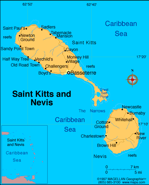
Map of St.
Kitts and Nevis
Federation of St. Kitts and Nevis
Sovereign: Queen Elizabeth II
(1952)
Governor-General: Sir Edmund Lawrence (2013)
Prime Minister: Timothy Harris
(2015)
Total area: 101 sq mi (261 sq km). St. Kitts,
65 sq mi (168 sq km); Nevis, 36 sq mi (93 sq km)
Population (2014 est.): 51,538 (growth
rate: 0.78%); birth rate: 13.64/1000; infant mortality rate:
8.98/1000; life expectancy: 75.29; density per sq mi: 424
Capital (2011 est.):
Basseterre (on St. Kitts), 12,000
Largest town on Nevis: Charlestown,
1,538
Monetary unit: East Caribbean
dollar
Language: English
Ethnicity/race:
predominantly black; some British, Portuguese,
and Lebanese
Religions:
Anglican, other Protestant, Roman Catholic
Literacy rate: 97.8% (2003 est.)
Economic summary: GDP/PPP (2013
est.): $952 million; per capita $16,300. Real growth rate:
1.9%. Inflation: 2.2%. Unemployment: 4.5% (1997).
Arable land: 19.23%. Agriculture: sugarcane, rice, yams,
vegetables, bananas; fish. Labor force: 18,170 (June 1995).
Industries: tourism, cotton, salt, copra, clothing, footwear, beverages. Natural resources: arable
land. Exports: $57.3 million (2013 est.): machinery, food,
electronics, beverages, tobacco. Imports: $355.4 million (2013
est.): machinery, manufactures, food, fuels. Major trading
partners: U.S., Canada, Bangladesh, Italy, Germany, Barbados, Trinidad and
Tobago (2012).
Communications: Telephones: main lines
in use: 20,000 (2012); mobile cellular: 84,000 (2012). Radio
broadcast stations: 15 (2007).
Radios: 28,000 (1997). Television broadcast stations:
2 (plus 3 repeaters) (2003). Televisions: 10,000 (1997).
Internet Service Providers (ISPs): 54 (2012). Internet
users: 17,000 (2009).
Transportation: Railways: total: 50 km
(2008). Highways: total: 383 km; paved: 163 km; unpaved: 220
km (2006 est.). Ports and harbors: Basseterre, Charlestown.
Airports: 2 (2013).
International disputes: Joins
other Caribbean states to counter Venezuela's claim that Aves Island
sustains human habitation, a criterion under United Nations Convention
on the Law of the Sea, which permits Venezuela to extend its Economic
Exclusion Zone/continental shelf over a large portion of the eastern
Caribbean Sea.
-------------------- o --------------------
No comments:
Post a Comment