ST. LUCIA
Geography: One of the Windward Islands of the eastern Caribbean, St. Lucia lies just south of Martinique. It is of volcanic origin. A chain of wooded mountains runs from north to south and from them flow many streams into fertile valleys.
Government: Parliamentary democracy. A governor-general represents the sovereign, Queen Elizabeth II.
History: The first inhabitants of St. Lucia were the Arawak Indians, who were forced off the island by the Caribs. Explored by Spain and then France, St. Lucia became a British territory in 1814 and one of the Windward Islands in 1871. With other Windward Islands, St. Lucia was granted home rule in 1967 as one of the West Indies Associated States. On Feb. 22, 1979, St. Lucia achieved full independence in ceremonies boycotted by the opposition St. Lucia Labour Party, which had advocated a referendum before cutting ties with Britain. John Compton, head of the United Workers Party (UWP), became the country's first prime minister. The UWP, then in power, called for new elections and was defeated by the St. Lucia Labour Party (SLP). The UWP, with Compton as its leader, was returned to power in the elections of 1982, 1987, and 1992. Compton resigned in 1996 and Vaughan Lewis took over as prime minister.
Kenny Anthony became prime minister in 1997, when his St. Lucia Labour Party won 16 of the 17 parliamentary seats.
The 1999 European Union decision to end its preferential treatment of bananas imported from former colonies has led St. Lucia to try to diversify its agricultural crops. In 2002, tropical storm Lili devasted the banana crop.
In 2006, Sir John Compton, often called the "Father of St. Lucia," returned to politics five years after retiring, and his UWP swept elections. He became prime minister once again, at age 82. He died in 2007 and was succeeded by Stephenson King.
In November 2011, Kenny Anthony became prime minister again after the St. Lucia Labour Party won 11 of the 17 seats in Parliament. Anthony previously served as prime minister from 1997 to 2006.
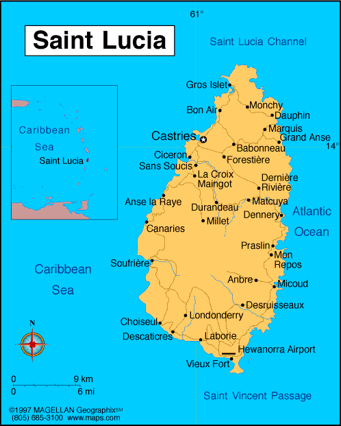
Map of St. Lucia
Sovereign: Queen Elizabeth II
(1952)
Governor-General: Dame Pearlette
Louisy (1997)
Prime Minister: Kenny Anthony (2011)
Land area: 236 sq mi (611 sq km); total
area: 238 mi (616 sq km)
Population (2014 est.): 163,362 (growth
rate: 0.35%); birth rate: 13.94/1000; infant mortality rate:
11.75/1000; life expectancy: 77.41; density per sq mi: 672
Capital and largest city (2011 est.):
Castries, 21,000
Monetary unit: East Caribbean
dollar
Languages:
English (official), French patois
Ethnicity/race:
black 85.3%, mixed 10.9%, East Indian 2.2%,
other or unspecified 1.7% (2010 est.)
Religions:
Roman Catholic 61.5%, Seventh-Day Adventist 10.4%,
Pentecostal 8.9%, Evangelical 2.3%, Anglican 1.6%, other Christian 3.4%,
Rastafarian 1.9%, none 5.9% (2010 est.)
Literacy rate: 90.1% (2001 est.)
Economic summary: GDP/PPP (2013
est.): $2.216 billion; per capita $13,100. Real growth rate:
0.2%. Inflation: 5.3%. Unemployment: 20% (2003 est.).
Arable land: 4.84% (2011 est.). Agriculture: bananas,
coconuts, vegetables, citrus, root crops, cocoa. Labor force:
79,700 (2012 est.); agriculture 21.7%, industry, commerce, and
manufacturing 24.7%, services 53.6% (2002 est.). Industries:
tourism; clothing, assembly of electronic components,
beverages, corrugated cardboard boxes, lime processing, coconut
processing.
Natural resources: forests, sandy beaches, minerals (pumice), mineral springs, geothermal potential. Exports: $206.8 million
(2013 est.): bananas 41%, clothing, cocoa, avocados, mangoes, coconut oil. Imports: $592.7 million (2013 est.): food 23%, manufactured goods 21%, machinery and transportation equipment 19%, chemicals, fuels. Major trading partners: UK, U.S., Brazil, Peru, France, Grenada, Barbados, Antigua and Barbuda, Dominica, Trinidad and Tobago (2012).
Member of Commonwealth of Nations
Communications: Telephones: main lines
in use: 36,800 (2012); mobile cellular: 227,000 (2012). Radio
broadcast stations: AM 2, FM 7 (plus 3 repeaters), shortwave 0
(2003). Radios: 111,000 (1997). Television broadcast
stations: 3 (2 commercial broadcast stations and 1 community
antenna television or CATV channel) (2007). Televisions:
32,000 (1997). Internet Service Providers (ISPs): 100 (2012).
Internet users: 142,900 (2009).
Transportation: Railways: 0 km.
Highways: total: 1,210 km (2011 est.).
Ports and harbors: Castries, Cul-de-Sac, Vieux-Fort.
Airports: 2 (2013).
International disputes:
joins other Caribbean states to counter Venezuela's claim that Aves
Island sustains human habitation, a criterion under United Nations
Convention on the Law of the Sea, which permits Venezuela to extend its
Economic Exclusion Zone/continental shelf over a large portion of the
eastern Caribbean Sea.
-------------------- o --------------------
No comments:
Post a Comment