ST. VINCENT & GRENADINES
Geography: St. Vincent, chief island of the chain, is 18 mi (29 km) long and 11 mi (18 km) wide and is located 100 mi (161 km) west of Barbados. The island is mountainous and well forested. St. Vincent is dominated by the volcano Mount Soufrière, which rises to 4,048 ft (1,234 m). The Grenadines, a chain of nearly 600 islets with a total area of only 17 sq mi (27 sq km), extend for 60 mi (96 km) between St. Vincent and Grenada. The main islands in the Grenadines are Bequia, Balliceau, Canouan, Mayreau, Mustique, Isle D'Quatre, Petit Saint Vincent, and Union Island.
Government: Parliamentary democracy.
History: The Carib Indians inhabited St. Vincent before the Europeans arrived, and the island still sports a sizable number of Carib artifacts. Explored by Columbus in 1498, and alternately claimed by Britain and France, St. Vincent became a British colony by the Treaty of Paris in 1763. In 1773, the island was divided between the Caribs and the British, but conflicts between the groups persisted. In 1776, the Caribs revolted and were subdued. Thereafter the British deported most of them to islands in the Gulf of Honduras. Sugarcane cultivation brought thousands of African slaves and, later, Portuguese and East Indian laborers.
The islands belonged to the West Indies Federation from 1958 until its dissolution in 1962, won home rule in 1969 as part of the West Indies Associated States, and achieved full independence Oct. 27, 1979. Prime Minister Milton Cato's government quelled a brief rebellion on Dec. 8, 1979, attributed to economic problems following the eruption of Mount Soufrière in April 1979 (which had caused the evacuation of the northern two-thirds of the island). The eruption, followed by Hurricane Allen in 1980, seriously damaged the nation's economy, particularly the important banana crop, in the 1980s. But by the 1990s the economy had begun to rebound. With the 1999 decision by the European Union to end its preferential treatment of bananas imported from former colonies, St. Vincent sought to diversify its economy, primarily through expanding tourism.
In 2001 elections, the Unity Labour Party (ULP) won a landslide upset, and Ralph Gonsalves, a lawyer, became the new prime minister. In 2005, he was reelected.
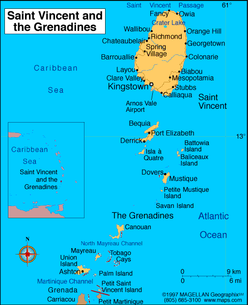
Map of St. Vincent
and Grenadines
Sovereign: Queen Elizabeth II
(1952)
Governor-General: Frederick
Ballantyne (2002)
Prime Minister: Ralph Gonsalves
(2001)
Total area: 150 sq mi (389 sq km)
Population (2014 est.): 102,918 (growth
rate: -0.29%); birth rate: 13.85/1000; infant mortality rate:
13.07/1000; life expectancy: 74.86; density per sq mi: 792
Capital and largest city (2011 est.):
Kingstown, 31,000
Monetary unit: East Caribbean
dollar
Languages:
English, French patois
Ethnicity/race:
black 66%, mixed 19%, East Indian 6%, European 4%, Carib
Amerindian 2%, other 3%
Religions:
Anglican 47%, Methodist 28%, Roman Catholic
13%, Hindu, Seventh-Day Adventist, other Protestant 12%
Literacy rate: 96% (1970 est.)
Economic summary: GDP/PPP (2013
est.): $1.335 billion; per capita $12,100. Real growth rate:
2%. Inflation: 2.8%. Unemployment: 18.8% (2008
est.). Arable land: 12.82%. Agriculture: bananas,
coconuts, sweet potatoes, spices; small numbers of cattle, sheep,
pigs, goats; fish. Labor force: 57,520 (2007 est);
agriculture 26%, industry 17%, services 57% (1980 est.).
Industries: tourism; food processing, cement, furniture, clothing, starch. Natural resources: hydropower, cropland.
Exports: $45.7 million (2013): bananas, eddoes and dasheen
(taro), arrowroot starch, tennis racquets. Imports: $301.5
million (2013): foodstuffs, machinery and equipment, chemicals and
fertilizers, minerals and fuels. Major trading partners:
Barbados, St. Lucia, Trinidad and Tobago, Antigua and Barbuda, U.S.,
Grenada, Dominica, Turkey, Dominica, Singapore, China (2012).
Member of Commonwealth of Nations
Communications: Telephones: main lines
in use: 19,400 (2012); mobile cellular: 135,500 (2012) Radio
broadcast stations: AM 1, FM 10, shortwave 0 (2009).
Radios: 77,000 (1997). Television broadcast stations:
1 (plus three repeaters) (2007). Televisions: 18,000 (1997).
Internet Service Providers (ISPs): 305 (2012). Internet
users: 76,000 (2009).
Transportation: Railways: 0 km.
Highways: total: 829 km; paved: 580 km; unpaved: 249 km
(2003 est.). Ports and harbors: Kingstown. Airports: 6
(2013).
International disputes: Joins
other Caribbean states to counter Venezuela's claim that Aves Island
sustains human habitation, a criterion under United Nations Convention
on the Law of the Sea, which permits Venezuela to extend its Economic
Exclusion Zone/continental shelf over a large portion of the eastern
Caribbean Sea.
-------------------- o --------------------
No comments:
Post a Comment