SUDAN
Geography: Sudan, in northeast Africa, measures about one-fourth the size of the United States. Its neighbors are Chad and the Central African Republic on the west, Egypt and Libya on the north, Ethiopia and Eritrea on the east, and South Sudan, Kenya, Uganda, and Democratic Republic of the Congo on the south. The Red Sea washes about 500 mi of the eastern coast. It is traversed from north to south by the Nile, all of whose great tributaries are partly or entirely within its borders.
Government: Military government.
History: What is now northern Sudan was in ancient times the kingdom of Nubia, which came under Egyptian rule after 2600 B.C. An Egyptian and Nubian civilization called Kush flourished until A.D. 350. Missionaries converted the region to Christianity in the 6th century, but an influx of Muslim Arabs, who had already conquered Egypt, eventually controlled the area and replaced Christianity with Islam. During the 1500s a people called the Funj conquered much of Sudan, and several other black African groups settled in the south, including the Dinka, Shilluk, Nuer, and Azande. Egyptians again conquered Sudan in 1874, and after Britain occupied Egypt in 1882, it took over Sudan in 1898, ruling the country in conjunction with Egypt. It was known as the Anglo-Egyptian Sudan between 1898 and 1955.
The 20th century saw the growth of Sudanese nationalism, and in 1953 Egypt and Britain granted Sudan self-government. Independence was proclaimed on Jan. 1, 1956. Since independence, Sudan has been ruled by a series of unstable parliamentary governments and military regimes. Under Maj. Gen. Gaafar Mohamed Nimeiri, Sudan instituted fundamentalist Islamic law in 1983. This exacerbated the rift between the Arab north, the seat of the government, and the black African animists and Christians in the south. Differences in language, religion, ethnicity, and political power erupted in an unending civil war between government forces, strongly influenced by the National Islamic Front (NIF) and the southern rebels, whose most influential faction is the Sudan People's Liberation Army (SPLA). Human rights violations, religious persecution, and allegations that Sudan had been a safe haven for terrorists isolated the country from most of the international community. In 1995, the UN imposed sanctions against it.
On Aug. 20, 1998, the United States launched cruise missiles that destroyed a pharmaceutical manufacturing facility in Khartoum which allegedly manufactured chemical weapons. The U.S. contended that the Sudanese factory was financed by Islamic militant Osama bin Laden.
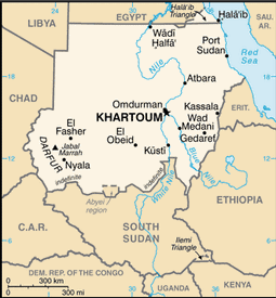
Map of Sudan
National
name: Jamhuryat as-Sudan
President:
Lt. Gen. Omar Hassan Ahmad al-Bashir (1989)
Current government officials
Total area: 1,156,673 sq mi (1,861,484 sq
km)
Population (2014 est.): 35,482,233 (growth
rate: 1.78%); birth rate: 30.01/1000; infant mortality rate: 52.86/1000;
life expectancy: 63.32; density per sq mi: 42.4
Capital (2011 est.):
Khartoum, 4.632 million
Largest cities:
Omdurman, 2,395,159; Port Sudan, 489,275
Monetary unit: Dinar
Languages:
Arabic (official), English (official), Nubian, Ta Bedawie, Fur
Ethnicity/race:
Sudanese Arab (approximately 70%), Fur, Beja, Nuba, Fallata
Religions:
Sunni Muslim, small Christian minority
Literacy rate: 71.9% (2011 est.)
Economic summary: GDP/PPP (2013 est.):
$89.97 billion; per capita $2,600. Real growth rate: 3.9%.
Inflation: 25%. Unemployment: 20% (2012 est.).
Arable land: 6.76%. Agriculture: cotton, groundnuts
(peanuts), sorghum, millet, wheat, gum arabic, sugarcane, cassava
(tapioca), mangos, papaya, bananas, sweet potatoes, sesame; sheep,
livestock. Labor force: 11.92 million (2007 est.); agriculture
80%, industry 7%, services 13% (1998 est.).
Industries: oil, cotton ginning, textiles, cement, edible oils,
sugar, soap distilling, shoes, petroleum refining, pharmaceuticals,
armaments, automobile/light truck assembly. Natural resources:
petroleum; small reserves of iron ore, copper, chromium ore, zinc,
tungsten, mica, silver, gold, hydropower. Exports: $4.145
billion (2013 est.): gold; oil and petroleum products; cotton, sesame, livestock, groundnuts, gum arabic, sugar. Imports:
$5.941 billion (2013 est.): foodstuffs, manufactured goods,
refinery and transport equipment, medicines and chemicals, textiles,
wheat. Major trading partners: Macau, Saudi Arabia, UAE,
Egypt, India, Germany, Ethiopia (2012).
Communications: Telephones: main lines in
use: 425,000 (2012); mobile cellular: 27.659 million (2012). Radio
broadcast stations: AM 12, FM 1, shortwave 1 (2007).
Radios: 7.55 million (1997). Television broadcast stations:
3 (1997). Televisions: 2.38 million (1997). Internet
Service Providers (ISPs): 99 (2012). Internet users: 4.2 million
(2008).
Transportation: Railways:
total: 5,978 km (2008). Highways: total: 11,900 km; paved:
4,320 km; unpaved: 7,580 km (2000 est.). Waterways: 4,068 km
navigable (2011). Ports and harbors: Port Sudan. Airports: 74 (2013).
International disputes:
the effects of Sudan's almost constant ethnic and rebel militia
fighting since the mid-20th century have penetrated all of the
neighboring states; Chad wishes to be a helpful mediator in resolving
the Darfur conflict, and in 2010 established a joint border monitoring
force with Sudan, which has helped to reduce cross-border banditry and
violence; as of mid-2013, Chad, Egypt, Ethiopia, Israel, the Central
African Republic, and South Sudan provided shelter for more than 600,000
Sudanese refugees; during the same period, Sudan, in turn, hosted about
115,000 Eritreans, 32,000 Chadians, and smaller numbers of Ethiopians
and Central Africans; Sudan accuses Eritrea of supporting Sudanese rebel
groups; efforts to demarcate the porous boundary with Ethiopia proceed
slowly due to civil and ethnic fighting in eastern Sudan; Sudan claims
but Egypt de facto administers security and economic development of the
Halaib region north of the 22nd parallel boundary; periodic violent
skirmishes with Sudanese residents over water and grazing rights persist
among related pastoral populations along the border with the Central
African Republic; South Sudan-Sudan boundary represents 1 January 1956
alignment, final alignment pending negotiations and demarcation; final
sovereignty status of Abyei Area pending negotiations between South
Sudan and Sudan.
-------------------- o --------------------
No comments:
Post a Comment