TANZANIA
Geography: Tanzania is in East Africa on the Indian Ocean. To the north are Uganda and Kenya; to the west, Burundi, Rwanda, and Congo; and to the south, Mozambique, Zambia, and Malawi. Its area is three times that of New Mexico. Tanzania contains three of Africa's best-known lakes—Victoria in the north, Tanganyika in the west, and Nyasa in the south. Mount Kilimanjaro in the north, 19,340 ft (5,895 m), is the highest point on the continent. The island of Zanzibar is separated from the mainland by a 22-mile channel.
Government: Republic.
History: Arab traders first began to colonize the area in 700. Portuguese explorers reached the coastal regions in 1500 and held some control until the 17th century, when the sultan of Oman took power. With what are now Burundi and Rwanda, Tanganyika became the colony of German East Africa in 1885. After World War I, it was administered by Britain under a League of Nations mandate and later as a UN trust territory.
Although not mentioned in old histories until the 12th century, Zanzibar was always believed to have had connections with southern Arabia. The Portuguese made it one of their tributaries in 1503 and later established a trading post, but they were driven from Oman by Arabs in 1698. Zanzibar was declared independent of Oman in 1861 and, in 1890, it became a British protectorate.
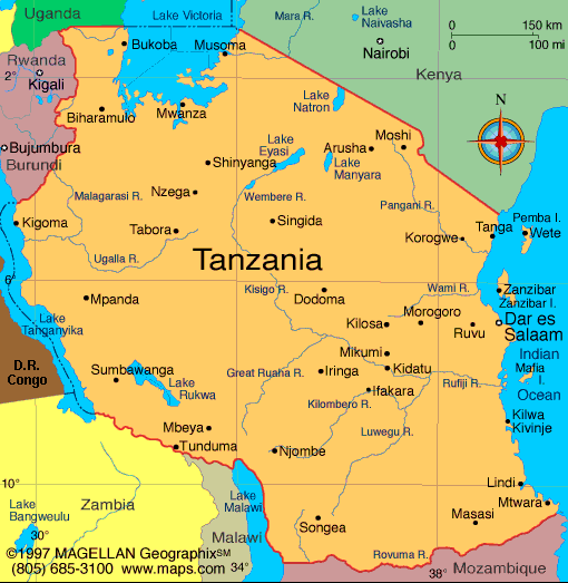
Map of Tanzania
President: Jakaya Kikwete (2005)
Prime Minister: Mizengo Pinda
(2008)
Land area: 342,100 sq mi (886,039 sq km);
total area: 364,898 sq mi (945,087 sq km)1
Population (2014 est.): 49,639,138
(growth rate: 2.8%); birth rate: 36.82/1000; infant mortality rate:
43.74/1000; life expectancy: 61.24; density per sq mi: 123.1
Capital (2011 est.):
Dar es Salaam, 3.588 million
Monetary unit: Tanzanian shilling
Languages:
Swahili, English (both official); Arabic; many
local languages
Ethnicity/race:
mainland: native African 99% (includes 95%
Bantu, consisting of more than 130 tribes), Asian, European, and
Arab 1%; Zanzibar: Arab, native African, mixed
Religions:
mainland: Christian 30%, Islam 35%, indigenous
35%; Zanzibar: more than 99% Islam
Literacy rate: 67.8% (2010 est.)
Economic summary: GDP/PPP (2013
est.): $79.29 billion; per capita $1,700. Real growth rate:
7%. Inflation: 7.8%. Unemployment: n.a. Arable
land: 12.25%. Agriculture: coffee, sisal, tea, cotton,
pyrethrum (insecticide made from chrysanthemums), cashew nuts,
tobacco, cloves, corn, wheat, cassava (tapioca), bananas, fruits,
vegetables; cattle, sheep, goats. Labor force (2013 est.): 25.59 million;
agriculture 80%, industry and services 20%.
Industries: agricultural processing (sugar,
beer, cigarettes, sisal twine); mining (diamonds, gold, and iron), salt,
soda ash; cement, oil refining, shoes, apparel, wood products,
fertilizer.
Natural resources: hydropower, tin, phosphates, iron ore,
coal, diamonds, gemstones, gold, natural gas, nickel.
Exports: $5.92 billion (2013 est.): gold, coffee,
cashew nuts, manufactures, cotton. Imports: $11.16 billion
(2013 est.): consumer goods, machinery and transportation
equipment, industrial raw materials, crude oil. Major trading
partners: India, Japan, China, Kenya,
South Africa, UAE, Germany (2012).
Member of Commonwealth of Nations
Communications: Telephones: main lines
in use: 161,100 (2011); mobile cellular: 27.22 million (2012). Radio
broadcast stations: a state-owned TV station and multiple
privately-owned TV stations; state-owned national radio station
supplemented by more than 40 privately-owned radio stations;
transmissions of several international broadcasters are available
(2007).
Radios: 8.8 million (1997). Television broadcast
stations: 3 (1999). Televisions: 103,000 (1997).
Internet Service Providers (ISPs): 26,074 (2012). Internet
users: 678,000 (2009).
Transportation: Railways: total: 3,689
km (2008). Highways: total: 86,472 km; paved: 7,092 km;
unpaved: 79,380 km (2010 est.). Waterways: Lake Tanganyika,
Lake Victoria, Lake Nyasa. Ports and harbors: Bukoba, Dar es
Salaam, Kigoma, Kilwa Masoko, Lindi, Mtwara, Mwanza, Pangani, Tanga,
Wete, Zanzibar. Airports: 166 (2013).
International disputes:
Dispute with Tanzania over the boundary in Lake Nyasa (Lake Malawi) and
the meandering Songwe River; Malawi contends that the entire lake up to
the Tanzanian shoreline is its territory, while Tanzania claims the
border is in the center of the lake; the conflict was reignited in 2012
when Malawi awarded a license to a British company for oil exploration
in the lake.
-------------------- o --------------------
No comments:
Post a Comment