TOGO
Geography: Togo, twice the size of Maryland, is on the south coast of West Africa bordering on Ghana to the west, Burkina Faso to the north, and Benin to the east. The Gulf of Guinea coastline, only 32 mi long (51 km), is low and sandy. The only port is at Lomé. The Togo hills traverse the central section.
Government: Republic transitioning to multiparty democratic rule.
History: The Voltaic peoples and the Kwa were the earliest known inhabitants. The Ewe followed in the 14th century and the Ane in the 18th century. The Danish claimed the land in the 18th century, but by 1884 it was established as a German colony (Togoland). The area was split between the British and the French under League of Nations mandates after World War I and subsequently administered as UN trusteeships. The British portion voted for incorporation with Ghana. The French portion became Togo, which declared its independence on April 27, 1960.
Togo's first democratically elected president, Sylvano Olympius, was overthrown in 1963. He was shot and killed by Sgt. Etienne Eyadema while he attempted to scale the walls of the American Embassy to seek asylum. The government of Nicolas Grunitzky was overthrown in a bloodless coup on Jan. 13, 1967, led by Lt. Col. Etienne Eyadema (now called Gen. Gnassingbé Eyadema). A National Reconciliation Committee was set up to rule the country, but in April, Eyadema dissolved the committee and took over as president. He suspended the constitution, banned political parties, and created a cult of personality around his presidency; his official biography describes him as a “force of nature.” Under pressure from the West, Eyadema legalized opposition parties in 1993, but the first multiparty presidential election in Aug. 1993 (which gave Eyadema more than 96% of the vote) was considered fraudulent, as was his 1998 reelection. In Feb. 2005, Eyadema died—he had been Africa's longest-serving ruler (38 years). A day after his death, the military installed his son, Faure Gnassingbe, to serve out his term. Gnassingbe took office on Feb. 7 amid strong international condemnation. Under internal and external pressure, Gnassingbe stepped down later that month and agreed to elections on April 24. Violent protests surrounded the elections, and these protests grew when the results were announced: Gnassingbe won 60% of the vote while main opposition candidate Bob Akitani received 38%. On May 4, Gnassingbe was sworn into office. In June, Gnassingbe appointed opposition leader Edem Kodjo as prime minister.
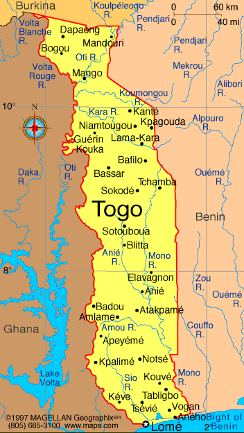
Map of Togo
President: Faure Gnassingbe (2005)
Prime Minister: Komi Sélom Klassou
(2015)
Land area: 21,000 sq mi (54,390 sq km);
total area: 21,925 sq mi (56,785 sq km)
Population (2014 est.): 7,351,374 (growth
rate: 2.71%); birth rate: 34.52/1000; infant mortality rate: 46.73/1000;
life expectancy: 64.06; density per sq mi: 301.9
Capital and largest city (2011 est.):
Lomé, 1.524 million
Monetary unit: CFA Franc
Togolese Republic
National
name: République Togolaise
Languages:
French (official, commerce); Ewé, Mina (south);
Kabyé, Dagomba (north)
Ethnicity/race:
native African (37 tribes; largest and most
important are Ewe, Mina, and Kabre) 99%, European and Syrian-Lebanese
less than 1%
Religions:
Indigenous beliefs 51%, Christian 29%, Islam
20%
Literacy rate: 60.4% (2011
est.)
Economic summary: GDP/PPP
(2013 est.): $7.348 billion; per capita $1,100. Real growth rate:
5.5%. Inflation: 2.2%. Unemployment: n.a. Arable
land: 44.2%. Agriculture: coffee, cocoa, cotton, yams,
cassava (tapioca), corn, beans, rice, millet, sorghum; livestock;
fish. Labor force: 2.595 million (2007); agriculture 65%,
industry 5%, services 30% (1998 est.). Industries: phosphate
mining, agricultural processing, cement, handicrafts, textiles,
beverages. Natural resources: phosphates, limestone, marble,
arable land. Exports: $982.2 million (2013 est.):
reexports, cotton, phosphates, coffee, cocoa. Imports: $1.677
billion (2013 est.): machinery and equipment, foodstuffs,
petroleum products. Major trading partners: Burkina Faso,
Ghana, Benin, Netherlands, Niger, China, India, France, Lebanon, UK (2012).
Communications: Telephones: main lines in
use: 225,000 (2012); mobile cellular: 3.518 million (2012). Radio broadcast
stations: 2 state-owned TV stations with multiple
transmission sites; 5 private TV stations broadcast locally; cable TV
service is available; state-owned radio network with multiple stations;
several dozen private radio stations and a few community radio stations;
transmissions of multiple international broadcasters available (2007). Radios: 940,000
(1997). Television broadcast stations: 3 (plus two repeaters)
(1997). Televisions: 73,000 (1997). Internet Service
Providers (ISPs): 1,168 (2012). Internet users: 356,300
(2009).
Transportation: Railways:
total: 568 km (2008). Highways: total: 11,652 km; paved: 2,447
km; unpaved: 9,205 km (2007 est.). Waterways: 50 km Mono river.
Ports and harbors: Kpeme, Lome. Airports: 8
(2013).
International disputes: in 2001
Benin claimed Togo moved boundary monuments - joint commission
presently resurveying the boundary.
-------------------- o --------------------
No comments:
Post a Comment