TRINIDAD & TOBAGO
Geography: Trinidad and Tobago lie in the Caribbean Sea off the northeast coast of Venezuela. Trinidad, the larger at 1,864 sq mi (4,828 sq km), is mainly flat and rolling, with mountains in the north that reach a height of 3,085 ft (940 m) at Mount Aripo. Tobago, at just 116 sq mi (300 sq km), is heavily forested with hardwood trees.
Government: Parliamentary democracy.
History: When Trinidad was explored by Columbus in 1498, it was inhabited by the Arawaks; Carib Indians inhabited Tobago. Trinidad remained in Spanish possession, despite raids by other European nations, until it was ceded to Britain in 1802. Tobago passed between Britain and France several times, but it was ultimately given to Britain in 1814. Slavery was abolished in 1834. Between 1845 and 1917, thousands of indentured workers were brought from India to work on sugarcane plantations. In 1889 Trinidad and Tobago were made a single colony.
Partial self-government was instituted in 1925, and from 1958 to 1962 the nation was part of the West Indies Federation. On Aug. 31, 1962, it gained independence and on Aug. 1, 1976, Trinidad and Tobago became a republic, remaining within the Commonwealth. While the country is a stable democracy and enjoys the highest living standards in the Caribbean thanks to oil revenue, tension between East Indians and blacks has underlined much of political life. In 1970 the tension was the underlying cause of riots, protests, and an army mutiny for the end of foreign influence over the economy. These events prompted a state of emergency which lasted for two years.
Eric Williams, “Father of the Nation” and leader of the People's National Movement (PNM), which is largely supported by blacks, governed from 1956 until his death in 1981. In Dec. 1986 the multiracial National Alliance for Reconstruction (NAR), based in Tobago, won a parliamentary majority, promising to sell most state-owned companies, reorganize the civil service, and reduce dependence on oil.
In 1990, to protest the NAR government, some 100 radical black Muslims blew up the police station in an attempted coup, in which the prime minister and other officials were held hostage for six days. The NAR was defeated in 1991, and the PNM returned to power. In 1995, the East Indian–based party, the United National Congress (UNC), led by Basdeo Panday, formed a coalition government with the NAR. In 2000, Panday narrowly won another term.
In Dec. 2001 elections, the governing UNC Party and the PNM Party gained 18 seats each. The two parties agreed to allow President Robinson to select the prime minister to end the impasse. But when Robinson chose Patrick Manning of the PNM because of his “moral and spiritual values,” the opposition angrily called for new elections. In the Oct. 2002 elections, Manning's party declared victory. Maxwell Richards, a university dean, was selected president by parliament in 2003.
In April 2006, former prime minister Panday was sentenced to two years in prison for committing fraud in public office. Richards, running unopposed, was reelected in February 2008.
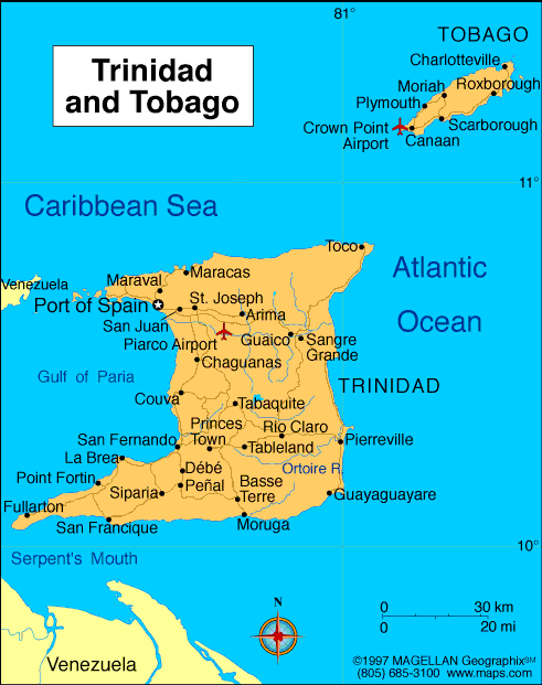
Map of
Trinidad & Tobago
President: Anthony Carmona (2013)
Prime Minister: Kamla Persad-Bissessar
(2010)
Total area: 1,981 sq mi (5,131 sq km)
Population (2014 est.): 1,223,916
(growth rate: –0.086%); birth rate: 13.8/1000; infant mortality rate:
24.82/1000; life expectancy: 72.29; density per sq mi: 659.2
Capital and largest city (2011 est.):
Port-of-Spain, 66,000
Monetary unit: Trinidad and Tobago
dollar
Languages:
English (official), Hindi, French, Spanish,
Chinese
Ethnicity/race:
East Indian 35.4%, African 34.2%, mixed - other 15.3%, mixed African/East Indian 7.7%, other 1.3%, unspecified 6.2% (2011 est.)
Religions:
Protestant 32.1% (Pentecostal/Evangelical/Full Gospel
12%, Baptist 6.9%, Anglican 5.7%, Seventh-Day Adventist 4.1%,
Presbyterian/Congretational 2.5, other Protestant .9), Roman Catholic
21.6%, Hindu 18.2%, Muslim 5%, Jehovah's Witness 1.5%, other 8.4%, none
2.2%, unspecified 11.1% (2011 est.)
Literacy rate: 98.8% (2011 est.)
Economic summary: GDP/PPP (2013
est.): $27.14 billion; per capita $20,300. Real growth rate:
1.6%. Inflation: 5.4%. Unemployment: 5.9%. Arable
land: 4.87%. Agriculture: cocoa, rice, citrus, coffee,
vegetables; poultry; sugar. Labor force: 621,000 (2013 est.); construction and
utilities 20.4%, manufacturing, mining, and quarrying 12.8%,
agriculture 3.8%, services 62.9% (2007 est.). Industries:
petroleum and petroleum products, liquefied natural gas (LNG),
methanol, ammonia, urea, steel products, beverages, food processing,
cement, cotton textiles. Natural resources: petroleum, natural gas,
asphalt. Exports: $12.86 billion (2013
est.):
petroleum and petroleum products, liquefied natural gas,
methanol, ammonia, urea, steel products, beverages, cereal and cereal
products, sugar, cocoa, coffee, citrus fruit, vegetables, flowers. Imports:
$9.638 billion (2013 est.): mineral fuels, lubricants,
machinery, transportation equipment, manufactured goods, food,
chemicals, live animals. Major trading
partners: U.S., Brazil, Gabon, China, Canada, Spain, Chile, Argentina, Colombia (2012).
Member of Commonwealth of Nations
Communications: Telephones: main lines
in use: 287,000 (2012); mobile cellular: 1.884 million (2012). Radio
broadcast stations: 5 TV networks, one of which is
state-owned, broadcast on multiple stations; multiple cable TV
subscription service providers; multiple radio networks, one
state-owned, broadcast over about 35 stations (2007).
Radios: 680,000 (1997). Television broadcast stations:
4 (1997). Televisions: 425,000 (1997). Internet
Service Providers (ISPs): 241,690 (2012). Internet users:
593,000 (2009).
Transportation: Railways: minimal
agricultural railroad system near San Fernando; railway service was
discontinued in 1968 (2001). Highways: total: 8,320 km;
paved: 4,252 km; unpaved: 4,068 km (2001). Ports and
harbors: Point Fortin, Point Lisas,
Port-of-Spain, Scarborough. Airports: 4
(2013).
International disputes: Barbados
and Trinidad and Tobago abide by the April 2006 Permanent Court of
Arbitration decision delimiting a maritime boundary and limiting catches
of flying fish in Trinidad and Tobago's exclusive economic zone; in
2005, Barbados and Trinidad and Tobago agreed to compulsory
international arbitration under United Nations Convention on the Law of
the Sea challenging whether the northern limit of Trinidad and Tobago's
and Venezuela's maritime boundary extends into Barbadian waters; Guyana
has also expressed its intention to include itself in the arbitration as
the Trinidad and Tobago-Venezuela maritime boundary may extend into its
waters as well.
-------------------- o --------------------
No comments:
Post a Comment