UGANDA

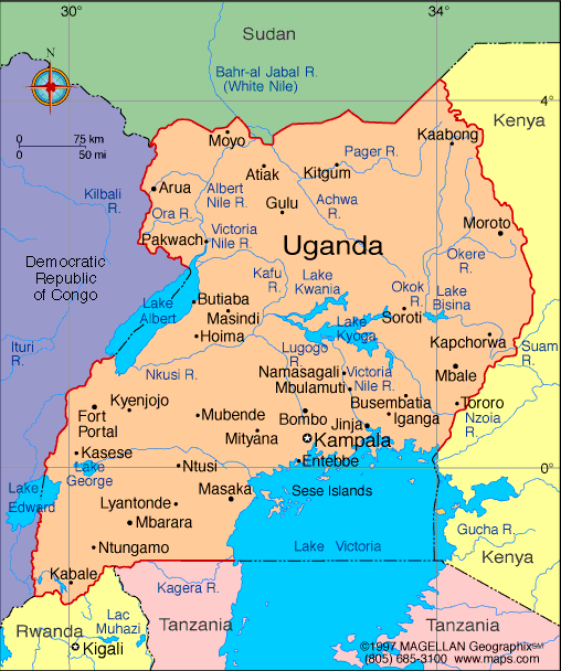
Geography: Uganda, twice the size of Pennsylvania, is in East Africa. It is bordered on the west by Congo, on the north by the Sudan, on the east by Kenya, and on the south by Tanzania and Rwanda. The country, which lies across the equator, is divided into three main areas—swampy lowlands, a fertile plateau with wooded hills, and a desert region. Lake Victoria forms part of the southern border.
Government: Multiparty democractic republic.
History: About 500 B.C. Bantu-speaking peoples migrated to the area now called Uganda. By the 14th century, three kingdoms dominated, Buganda (meaning "state of the Gandas"), Bunyoro, and Ankole. Uganda was first explored by Europeans as well as Arab traders in 1844. An Anglo-German agreement of 1890 declared it to be in the British sphere of influence in Africa, and the Imperial British East Africa Company was chartered to develop the area. The company did not prosper financially, and in 1894 a British protectorate was proclaimed. Few Europeans permanently settled in Uganda, but it attracted many Indians, who became important players in Ugandan commerce.
Uganda became independent on Oct. 9, 1962. Sir Edward Mutesa, the king of Buganda (Mutesa II), was elected the first president, and Milton Obote the first prime minister, of the newly independent country. With the help of a young army officer, Col. Idi Amin, Prime Minister Obote seized control of the government from President Mutesa four years later.

Map of Uganda
President: Yoweri Museveni (1986)
Prime Minister: Ruhakana Rugunda (2014)
Land area: 77,108 sq mi (199,710 sq km);
total area: 91,135 sq mi (236,040 sq km)
Population (2014 est.): 35,918,915 (growth rate: 3.24%); birth rate: 44.17/1000; infant mortality rate:
60.82/1000; life expectancy: 54.46
Capital and largest city (2011 est.):
Kampala, 1.659 million
Monetary unit: Ugandan new shilling
Republic of Uganda
Languages:
English (official national language, taught in
grade schools, used in courts of law and by most newspapers and some
radio broadcasts), Ganda or Luganda (most widely used of the
Niger-Congo languages, preferred for native language publications in
the capital and may be taught in school), other Niger-Congo languages,
Nilo-Saharan languages, Swahili, Arabic
Ethnicity/race:
Baganda 16.9%, Banyakole 9.5%, Basoga 8.4%,
Bakiga 6.9%, Iteso 6.4%, Langi 6.1%, Acholi 4.7%, Bagisu 4.6%, Lugbara
4.2%, Bunyoro 2.7%, other 29.6% (2002 census)
Religions:
Roman Catholic 41.9%, Protestant 42% (Anglican
35.9%, Pentecostal 4.6%, Seventh-Day Adventist 1.5%), Muslim 12.1%,
other 3.1%, none 0.9% (2002 census)
Literacy rate: 73.2% (2010 est.)
Economic summary: GDP/PPP (2013
est.): $54.37 billion; per capita $1,500. Real growth rate:
5.6%. Inflation: 6.2%. Unemployment: n.a.
Arable land: 27.94% (2011). Agriculture: coffee, tea, cotton,
tobacco, cassava (manioc, tapioca), potatoes, corn, millet, pulses, cut
flowers; beef, goat meat, milk, poultry. Labor force: 17.4 million (2013 est.); agriculture 82%, industry 5%, services 13%
(2011 est.). Industries: sugar, brewing, tobacco, cotton
textiles; cement, steel production. Natural resources:
copper, cobalt, hydropower, limestone, salt, arable land, gold.
Exports: $3.156 billion (2013 est.): coffee, fish and
fish products, tea, cotton, flowers, horticultural products; gold.
Imports: $4.858 billion (2013 est.): capital
equipment, vehicles, petroleum, medical supplies; cereals. Major
trading partners: Kenya, Rwanda, Democratic Republic of the Congo, UAE, Netherlands, Germany, China, India, South Africa, Japan, Italy (2012).
Member of the Commonwealth of Nations
Communications: Telephones: main lines
in use: 315,000 (2012);
mobile cellular: 16.355 million (2012). Broadcast media:
public broadcaster, Uganda Broadcasting Corporation (UBC), operates
radio and television networks; Uganda first began licensing
privately-owned stations in the 1990s; by 2007 there were nearly 150
radio and 35 TV stations, mostly based in and around Kampala;
transmissions of multiple international broadcasters are available in
Kampala (2007). Internet Service
Providers (ISPs):32,683 (2012). Internet users: 3.2 million (2009).
Transportation: Railways: total: 1,244
km (2008). Highways: total: 20,000 km; paved: 3,264 km; unpaved: 16,736 km (2011). Waterways:
there are no long navigable stretches of river in Uganda; parts of the
Albert Nile that flow out of Lake Albert in the northwestern part of
the country are navigable; several lakes including Lake Victoria and
Lake Kyoga have substantial traffic; Lake Albert is navigable along a
200-km stretch from its northern tip to its southern shores (2011). Ports and harbors: Entebbe, Jinja, Port Bell.
Airports: 47 (2013).
International disputes: Uganda
is subject to armed fighting among hostile ethnic groups, rebels, armed
gangs, militias, and various government forces that extend across its
borders; Uganda hosts 209,860 Sudanese, 27,560 Congolese, and 19,710
Rwandan refugees, while Ugandan refugees as well as members of the
Lord's Resistance Army (LRA) seek shelter in southern Sudan and the
Democratic Republic of the Congo's Garamba National Park; LRA forces
have also attacked Kenyan villages across the border.
-------------------- o --------------------
No comments:
Post a Comment