UZBEKISTAN
Geography: Uzbekistan is situated in central Asia between the Amu Darya and Syr Darya Rivers, the Aral Sea, and the slopes of the Tien Shan Mountains. It is bounded by Kazakhstan in the north and northwest, Kyrgyzstan and Tajikistan in the east and southeast, Turkmenistan in the southwest, and Afghanistan in the south. The republic also includes the Karakalpakstan Autonomous Republic, with its capital, Nukus (1992 est. pop., 182,000). The country is about one-tenth larger in area than the state of California.
Government: Republic; authoritarian presidential rule.
History: The Uzbekistan land was once part of the ancient Persian Empire and was later conquered by Alexander the Great in the 4th century B.C. During the 8th century, the nomadic Turkic tribes living there were converted to Islam by invading Arab forces who dominated the area. The Mongols under Ghengis Khan took over the region from the Seljuk Turks in the 13th century, and it later became part of Tamerlane the Great's empire and that of his successors until the 16th century. The Uzbeks invaded the territory in the early 16th century and merged with the other inhabitants in the area. Their empire broke up into separate Uzbek principalities, the khanates of Khiva, Bukhara, and Kokand. These city-states resisted Russian expansion into the area but were conquered by the Russian forces in the mid-19th century.
The territory was made into the Uzbek Republic in 1924 and became the independent Uzbekistan Soviet Socialist Republic in 1925. Under Soviet rule, Uzbekistan concentrated on growing cotton with the help of irrigation, mechanization, and chemical fertilizers and pesticides, causing serious environmental damage.
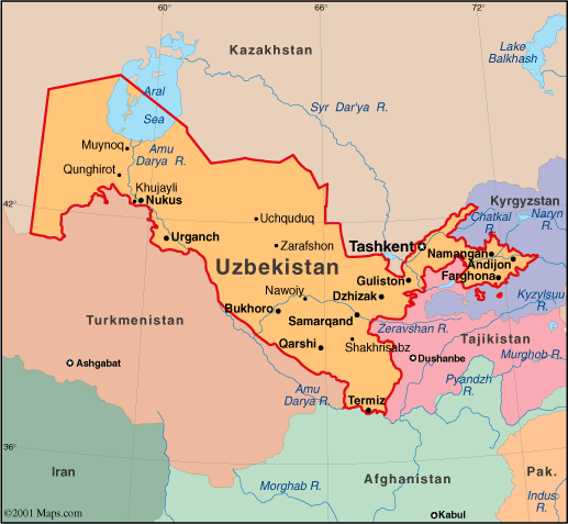
Map of
Uzbekistan
President: Islam A. Karimov (1990)
Prime Minister: Shavkat Mirziyayev
(2003)
Land area: 164,247 sq mi
(425,400 sq km); total area: 172,741 sq mi (447,400 sq
km)
Population (2014 est.): 28,929,716
(growth rate: 0.93%); birth rate: 17.02/1000; infant mortality rate:
19.84/1000; life expectancy: 73.29; density per sq mi: 159.1
Capital and largest city (2011
est.):Tashkent, 2.227 million
Other large
cities: Namangan, 1.565 million; Andijan, 1.448 million; Samarkand, 1.309 million
Monetary unit: Uzbekistani sum
National
name: Ozbekiston Respublikasi
Languages:Uzbek
74.3%, Russian 14.2%, Tajik 4.4%, other 7.1%
Ethnicity/race:Uzbek 80%, Russian 5.5%, Tajik 5%, Kazak 3%, Karakalpak 2.5%, Tatar
1.5%, other 2.5% (1996 est.)
Religions:Islam
(mostly Sunnis) 88%, Eastern Orthodox 9%, other 3%
Literacy rate: 99.4% (2011 est.)
Economic summary: GDP/PPP (2013 est.):
$112.6 billion; per capita $3,800. Real growth rate: 7%.
Inflation: 10.1% officially; 22% based on analysis of consumer
prices. Unemployment: 4.9% officially, plus another 20%
underemployed. Arable land: 9.61%. Agriculture: cotton,
vegetables, fruits, grain; livestock. Labor force: 16.99 million
(2013); agriculture 25.9%, industry 13.2%, services 60.9% (2012).
Industries: textiles, food processing, machine building, metallurgy, mining, hydrocarbon extraction, chemicals. Natural
resources: natural gas, petroleum, coal, gold, uranium, silver,
copper, lead and zinc, tungsten, molybdenum. Exports: $14.91
billion (2013 est.): energy products, cotton, gold, mineral
fertilizers, ferrous and nonferrous metals, textiles, food products,
machinery, automobiles. Imports: $12.64 billion (2013 est.): machinery and equipment, foodstuffs, chemicals, ferrous and nonferrous metals. Major trading partners: Russia, China, Turkey,
Kazakhstan, Kyrgyzstan, Bangladesh, South Korea, Germany, Ukraine (2012).
Communications:
Telephones: main lines in use: 1.963 million (2012); mobile
cellular: 20.274 million (2012). Radio broadcast stations: AM 15,
FM 7, shortwave 10 (1998). Radios: 10.2 million (1997).
Television broadcast stations: 10 (2013).
Televisions: 6.4 million (1997). Internet Service Providers
(ISPs): 56,075 (2012). Internet users: 4.689 million (2009).
Transportation: Railways: total: 4,230 km
(2012) Highways: total: 86,496 km; paved: 75,511 km; unpaved:
10,985 km (2000). Waterways: 1,100 (2012). Ports and
harbors: Termiz (Amu Darya river). Airports: 53
(2013).
International disputes:
prolonged drought and cotton monoculture in Uzbekistan and
Turkmenistan created water-sharing difficulties for Amu Darya river
states; field demarcation of the boundaries with Kazakhstan commenced in
2004; border delimitation of 130 km of border with Kyrgyzstan is
hampered by serious disputes around enclaves and other areas.
-------------------- o --------------------
No comments:
Post a Comment