VANUATU
Geography: Vanuatu is an archipelago of 83 islands lying between New Caledonia and Fiji in the South Pacific. Largest of the islands is Espiritu Santo (875 sq mi; 2,266 sq km); others are Efate, Malekula, Malo, Pentecost, and Tanna.
Government: Republic.
History: The first settlers are believed to have arrived approximately 3,500 years ago from New Guinea and the Solomon Islands by canoe. The islands were sighted by Pedro Fernandes de Queiros of Portugal in 1606 and were charted by the British navigator James Cook in 1774, who named the archipelago New Hebrides, after the northern Scottish islands. Competing British and French claims to the islands led to the formation of a condominium government, allowing for joint British-French rule in 1906. The islands' plantation economy, based on imported Vietnamese labor, was prosperous until the 1920s, when markets for its products declined. Diseases brought by missionaries, sandalwood traders, and others helped reduce the population from approximately 1 million in 1800 to 45,000 in 1935. The islands served as a major Allied base in World War II. After the war, the indigenous Melanesians began lobbying for independence, which in 1980 the country achieved. It was then renamed Vanuatu.
A brief rebellion by French settlers and plantation workers on Espiritu Santo took place in May 1980. Britain, France, and Papua New Guinea sent soldiers, who quelled the revolt, which the new government said was financed by the Phoenix Foundation, a right-wing U.S. group.
In July 2002, former prime minister Barak Sope was convicted of forgery. Alfred Maseng was elected president in April 2004, but he was forced to step down when his criminal record was revealed. In Aug. 2004, Kalkot Mataskelekele was selected from 16 candidates as the new president. He is the country's first president to hold a university degree.
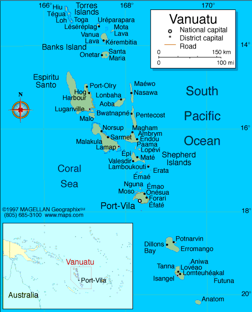
Map of Vanuatu
President: Baldwin Lonsdale (2014)
Prime Minister: Joe Natuman (2014)
Total area:
4,710 sq mi (12,200 sq km)
Population
(2014 est.): 266,937 (growth rate: 2.01%); birth rate: 25.69/1000;
infant mortality rate: 16.41/1000; life expectancy: 72.72; density per
sq mi: 51
Capital and largest city (2011
est.): Port Vila, 47,000
Monetary unit: Vatu
Republic of Vanuatu
Languages: Bislama 33.7% (a Melanesian pidgin English), English 2%, French 0.6% (all
3 official); other 0.5%; more than 100 local languages 63.2%
Ethnicity/race: Ni-Vanuatu 97.6%, part Ni-Vanuatu 1.1%, other 1.3% (2009 est.)
Religions:
Protestant 70% (includes Presbyterian 27.9%, Anglican 15.1%,
Seventh Day Adventist 12.5%, Assemblies of God 4.7%, Church of Christ
4.5%, Neil Thomas Ministry 3.1%, and Apostolic 2.2%), Roman Catholic
12.4%, customary beliefs 3.7% (including Jon Frum cargo cult), other
12.6%, none 1.1%, unspecified 0.2% (2009 est.)
Literacy
rate: 83.2% (2011 est.)
Economic
summary: GDP/PPP (2013 est.): $1.27 billion; per capita
$4,800. Real growth rate: 3.3%. Inflation: 1.9%.
Unemployment: 1.7% (1999). Arable land: 1.64%.
Agriculture: copra, coconuts, cocoa, coffee, taro, yams,
fruits, vegetables; beef; fish. Labor force: 115,900 (2007);
agriculture 65%, services 30%, industry 5% (2000 est.). Industries:
food and fish freezing, wood processing, meat canning. Natural
resources: manganese, hardwood forests, fish. Exports:
$43.1 million (2013 est.): copra, beef, cocoa, timber, kava,
coffee. Imports: $319.4 million (2013 est.): machinery
and equipment, foodstuffs, fuels. Major trading partners:
Thailand, Japan, China, Cote divoire, United States, Australia,
Singapore, New Zealand, Fiji (2012).
Communications: Telephones: main lines in
use: 5,800 (2012); mobile cellular: 137,000 (2012). Radio broadcast
stations: AM 2, FM 2, shortwave 1 (2008). Radios: 67,000
(1997). Television broadcast stations: 1 (2002).
Televisions: 2,300 (1999). Internet Service Providers
(ISPs): 5,655 (2012). Internet users: 17,000 (2009).
Transportation: Railways: 0 km.
Highways: total: 1,070 km; paved: 256 km; unpaved: 814 km (2000
est.). Waterways: none. Ports and harbors: Forari Bay, Luganville (Santo, Espiritu Santo), Port-Vila. Airports: 31 (2013).
International disputes: Matthew and Hunter
Islands east of New Caledonia claimed by Vanuatu and France.
-------------------- o --------------------
No comments:
Post a Comment