VIETNAM
Geography: Vietnam occupies the eastern and southern part of the Indochinese peninsula in Southeast Asia, with the South China Sea along its entire coast. China is to the north and Laos and Cambodia are to the west. Long and narrow on a north-south axis, Vietnam is about twice the size of Arizona. The Mekong River delta lies in the south.
Government: Communist state.
History: The Vietnamese are descendants of nomadic Mongols from China and migrants from Indonesia. According to mythology, the first ruler of Vietnam was Hung Vuong, who founded the nation in 2879 B.C. China ruled the nation then known as Nam Viet as a vassal state from 111 B.C. until the 15th century, an era of nationalistic expansion, when Cambodians were pushed out of the southern area of what is now Vietnam.
A century later, the Portuguese were the first Europeans to enter the area. France established its influence early in the 19th century, and within 80 years it conquered the three regions into which the country was then divided—Cochin-China in the south, Annam in the central region, and Tonkin in the north.
France first unified Vietnam in 1887, when a single governor-generalship was created, followed by the first physical links between north and south—a rail and road system. Even at the beginning of World War II, however, there were internal differences among the three regions. Japan took over military bases in Vietnam in 1940, and a pro-Vichy French administration remained until 1945. Veteran Communist leader Ho Chi Minh organized an independence movement known as the Vietminh to exploit the confusion surrounding France's weakened influence in the region. At the end of the war, Ho's followers seized Hanoi and declared a short-lived republic, which ended with the arrival of French forces in 1946.
Paris proposed a unified government within the French Union under the former Annamite emperor, Bao Dai. Cochin-China and Annam accepted the proposal, and Bao Dai was proclaimed emperor of all Vietnam in 1949. Ho and the Vietminh withheld support, and the revolution in China gave them the outside help needed for a war of resistance against French and Vietnamese troops armed largely by a United States worried about cold war Communist expansion.
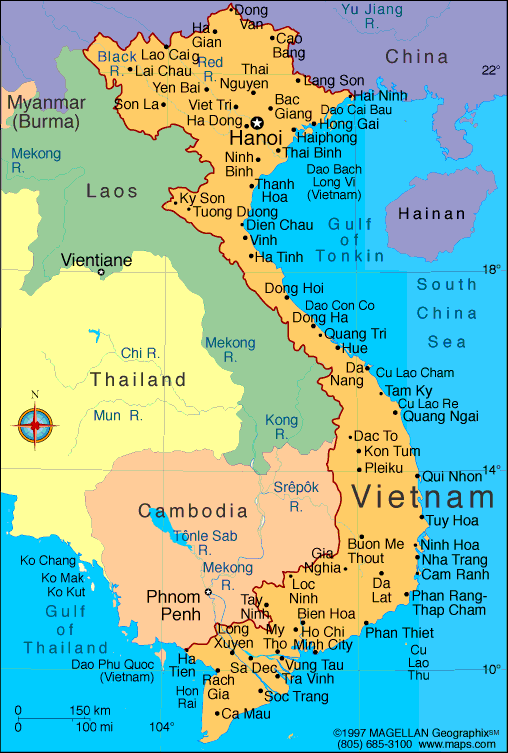
Map of Vietnam
President: Truong Tan Sang
(2011)
Prime Minister: Nguyen Tan
Dung (2006)
Land area: 125,622 sq mi (325,361 sq km);
total area: 127,244 sq mi (329,560 sq km)
Population (2014 est.): 93,421,835 (growth
rate: 1%); birth rate: 16.26/1000; infant mortality rate: 18.99/1000;
life expectancy: 72.91; density per sq mi: 703
Capital (2013 est.):
Hanoi, 7.1 million (metro. area), 2.955 million (city
proper)
Largest cities: Ho Chi
Minh City (Saigon), 8,190,775; Haiphong 925,000; Da Nang 834,000
Monetary unit:
Dong
National name: Công Hòa Xa Hôi Chú Nghia
Viêt Nam
Languages:
Vietnamese (official); English (increasingly
favored as a second language); some French, Chinese, Khmer; mountain
area languages (Mon-Khmer and Malayo-Polynesian)
Ethnicity/race:
Kinh (Viet) 85.7%, Tay 1.9%, Thai 1.8%, Muong 1.5%, Khmer 1.5%, Mong 1.2%, Nung 1.1%, others 5.3% (1999 census)
Religions:
Buddhist 9%, Catholic 7%, Hoa Hao 2%, Cao Dai
1%, Protestant, Islam, none 81%
Literacy rate: 93.4% (2011 est.)
Economic summary: GDP/PPP (2013 est.):
$358.9 billion; per capita $4,000. Real growth rate: 5.3%.
Inflation: 6.8%. Unemployment: 1.3%. Arable land:
19.64%. Agriculture: rice, coffee, rubber, tea, pepper, soybeans, cashews, sugar cane, peanuts, bananas; poultry; fish, seafood. Labor force: 52.93 million; agriculture 48%, industry 21%, services 31% (2013). Industries: food
processing, garments, shoes, machine-building; mining, coal, steel;
cement, chemical fertilizer, glass, tires, oil, mobile phones. Natural
resources: phosphates, coal, manganese, rare earth elements, bauxite, chromate, offshore oil and gas deposits, timber, hydropower. Exports:
$128.9 billion (2013 est.): clothes, shoes, electronics, seafood, crude oil, rice, coffee, wooden products, machinery. Imports:
$121.4 billion
(2013 est.): machinery and equipment, petroleum products, steel
products, raw materials for the clothing and shoe industries,
electronics, plastics, automobiles.
Major trading partners: U.S., Japan, China, Germany,
Singapore, UK, South Korea, Malaysia, Thailand (2012).
Communications: Telephones: main lines in
use: 10.191 million (2012); mobile cellular: 134.066 million (2012).
Radio broadcast stations: Government controls
all broadcast media exercising oversight through the Ministry of
Information and Communication (MIC); government-controlled national TV
provider, Vietnam Television (VTV), operates a network of 9 channels
with several regional broadcasting centers; programming is relayed
nationwide via a network of provincial and municipal TV stations; law
limits access to satellite TV but many households are able to access
foreign programming via home satellite equipment; government-controlled
Voice of Vietnam, the national radio broadcaster, broadcasts on 6
channels and is repeated on AM, FM, and shortwave stations throughout
Vietnam (2008).
Radios: 8.2 million (1997). Television broadcast stations:
at least 7 (plus 13 repeaters) (1998). Televisions: 3.57
million (1997). Internet Service Providers (ISPs): 189,553
(2012). Internet users: 23.382 million (2009).
Transportation: Railways: total: 2,632 km
(2008). Highways: total: 206,633 km; paved: 148,338 km;
unpaved: 47,130 km (2013 est.). Waterways: 47,130 km (30,831 km weight under 50 tons) (2013). Ports and harbors: Cam Ranh, Da Nang, Haiphong, Ho
Chi Minh City, Ha Long, Quy Nhon, Nha Trang, Vinh, Vung Tau.
Airports: 45 (2013).
International
disputes: Southeast Asian states have enhanced border
surveillance to check the spread of avian flu; Cambodia and Laos protest
Vietnamese squatters and armed encroachments along border; Cambodia
accuses Vietnam of a wide variety of illicit cross-border activities;
progress on a joint development area with Cambodia is hampered by an
unresolved dispute over sovereignty of offshore islands; an estimated
300,000 Vietnamese refugees reside in China; establishment of a maritime
boundary with Cambodia is hampered by unresolved dispute over the
sovereignty of offshore islands; the decade-long demarcation of the
China-Vietnam land boundary was completed in 2009; China occupies the
Paracel Islands also claimed by Vietnam and Taiwan; Brunei claims a
maritime boundary extending beyond as far as a median with Vietnam, thus
asserting an implicit claim to Lousia Reef; the 2002 "Declaration on
the Conduct of Parties in the South China Sea" has eased tensions but
falls short of a legally binding "code of conduct" desired by several of
the disputants; Vietnam continues to expand construction of facilities
in the Spratly Islands; in March 2005, the national oil companies of
China, the Philippines, and Vietnam signed a joint accord to conduct
marine seismic activities in the Spratly Islands; Economic Exclusion
Zone negotiations with Indonesia are ongoing, and the two countries in
Fall 2011 agreed to work together to reduce illegal fishing along their
maritime boundary.
-------------------- o --------------------
No comments:
Post a Comment