ZAMBIA
Geography: Zambia, a landlocked country in south-central Africa, is about one-tenth larger than Texas. It is surrounded by Angola, Zaire, Tanzania, Malawi, Mozambique, Zimbabwe, Botswana, and Namibia. The country is mostly a plateau that rises to 8,000 ft (2,434 m) in the east.
Government: Republic.
History: Early humans inhabited present-day Zambia between one and two million years ago. Today the country is made up almost entirely of Bantu-speaking peoples. Empire builder Cecil Rhodes obtained mining concessions in 1889 from King Lewanika of the Barotse and sent settlers to the area soon thereafter. The region was ruled by the British South Africa Company, which Rhodes established, until 1924, when the British government took over the administration.
From 1953 to 1964, Northern Rhodesia was federated with Southern Rhodesia (now Zimbabwe) and Nyasaland (now Malawi) in the Federation of Rhodesia and Nyasaland. On Oct. 24, 1964, Northern Rhodesia became the independent nation of Zambia.
Kenneth Kaunda, the first president, kept Zambia within the Commonwealth of Nations. The country's economy, dependent on copper exports, was threatened when Rhodesia declared its independence from British rule in 1965 and defied UN sanctions, which Zambia supported, an action that deprived Zambia of its trade route through Rhodesia. The U.S., Britain, and Canada organized an airlift in 1966 to ship gasoline into Zambia.
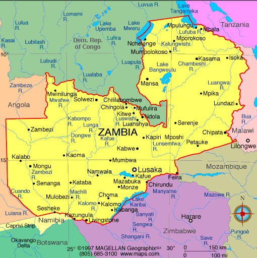
Map of Zambia
President: Edgar Lungu (2015)
Land area:
285,994 sq mi (740,724 sq km); total area: 290,586 sq mi (sq
km)
Population (2014 est.): 14,638,505
(growth rate: 2.88%); birth rate: 2.88/1000; infant mortality rate:
66.62/1000; life expectancy: 51.83.
Capital and largest city (2011
est.): Lusaka (capital) 1.802 million
Monetary unit: Kwacha
Republic of Zambia
Languages:
Bembe 33.4%, Nyanja 14.7%, Tonga 11.4%, Chewa 4.5%, Lozi 5.5%, Nsenga
2.9%, Tumbuka 2.5%, Lunda (North Western) 1.9%, Kaonde 1.8%, Lala 1.8%,
Lamba 1.8%, English (official) 1.7%, Luvale 1.5%, Mambwe 1.3%, Namwanga
1.2%, Lenje 1.1%, Bisa 1%, other 9.4%, unspecified 0.4% (2010 est.)
Ethnicity/race:
Bemba 21%, Tonga 13.6%, Chewa 7.4%, Lozi 5.7%, Nsenga 5.3%,
Tumbuka 4.4%, Ngoni 4%, Lala 3.1%, Kaonde 2.9%, Namwanga 2.8%, Lunda
(north Western) 2.6%, Mambwe 2.5%, Luvale 2.2%, Lamba 2.1%, Ushi 1.9%,
Lenje 1.6%, Bisa 1.6%, Mbunda 1.2%, other 13.8%, unspecified 0.4% (2010
est.)
Religions: Protestant 75.3%, Roman Catholic 20.2%, other 2.7% (includes Muslim Buddhist, Hindu, and Baha'i), none 1.8% (2010 est.)
Literacy rate: 61.4% (2007
est.)
Economic summary: GDP/PPP
(2013 est.): $25.47 billion; per capita $1,800. Real growth
rate: 6%. Inflation: 7.1%. Unemployment: 15%
(2008 est.). Arable land: 4.52%. Agriculture: corn,
sorghum, rice, peanuts, sunflower seeds, vegetables, flowers, tobacco,
cotton, sugarcane, cassava (manioc, tapioca), coffee; cattle, goats, pigs,
poultry, milk, eggs, hides. Labor force: 6.275 million (2013);
agriculture 85%, industry 6%, services 9% (2004). Industries:
copper mining and processing, emerald mining, construction, foodstuffs,
beverages, chemicals, textiles, fertilizer, horticulture. Natural resources: copper,
cobalt, zinc, lead, coal, emeralds, gold, silver, uranium, hydropower.
Exports: $8.547 billion (2013 est.): copper/cobalt,
cobalt, electricity, tobacco, flowers, cotton. Imports: $8.216
billion (2013 est.): machinery, transportation equipment,
petroleum products, electricity, fertilizer; foodstuffs, clothing.
Major trading partners: South Africa, China,
Democratic Republic of the Congo, Kuwait, South Korea, India, UAE, Egypt (2012).
Communications: Telephones: main lines
in use: 82,500 (2012); mobile cellular: 10.525 million (2012). Broadcast media:
State-owned Zambia National Broadcasting Corporation (ZNBC) operates 1
TV station and is the principal local-content provider; several private
TV stations are available; multi-channel subscription TV services are
obtainable; ZNBC operates 3 radio networks; about 2 dozen private radio
stations also broadcasting; relays of at least 2 international
broadcasters are accessible in Lusaka and Kitwe (2007). Internet Service
Providers (ISPs): 16,571 (2012). Internet users: 816,200 (2009).
Transportation: Railways:
total: 2,922 km (2013). Highways: total: 67,671 km; paved:
9,403 km ; unpaved: 31,051 km (2013 est.). Waterways: 2,250
km, including Zambezi and Luapula rivers, Lake Tanganyika. Ports
and harbors: Mpulungu. Airports: 88 (2013).
International conflicts:
In 2004, Zimbabwe dropped objections to plans between Botswana and
Zambia to build a bridge over the Zambezi River, thereby de facto
recognizing a short, but not clearly delimited, Botswana-Zambia boundary
in the river.
-------------------- o --------------------
No comments:
Post a Comment