ZIMBABWE
Geography: Zimbabwe, a landlocked country in south-central Africa, is slightly smaller than California. It is bordered by Botswana on the west, Zambia on the north, Mozambique on the east, and South Africa on the south.
Government: Parliamentary democracy.
History: The remains of early humans, dating back 500,000 years, have been discovered in present-day Zimbabwe. The land's earliest settlers, the Khoisan, date back to 200 B.C. After a period of Bantu domination, the Shona people ruled, followed by the Nguni and Zulu peoples. By the mid-19th century the descendants of the Nguni and Zulu, the Ndebele, had established a powerful warrior kingdom.
The first British explorers, colonists, and missionaries arrived in the 1850s, and the massive influx of foreigners led to the establishment of the territory Rhodesia, named after Cecil Rhodes of the British South Africa Company. In 1923, European settlers voted to become the self-governing British colony of Southern Rhodesia. After a brief federation with Northern Rhodesia (now Zambia) and Nyasaland (now Malawi) in the post–World War II period, Southern Rhodesia (also known as Rhodesia) chose to remain a colony when its two partners voted for independence in 1963.
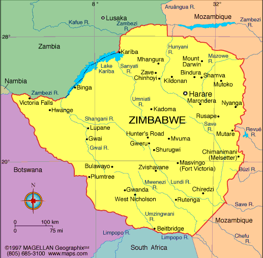
Map of Zimbabwe
President: Robert Mugabe (1980)
Land
area: 149,293 sq mi (386,669 sq km); total area: 150,804 sq
mi (390,580 sq km)
Population (2014
est.): 13,771,721 (growth rate: 4.36%); birth rate: 32.47/1000;
infant mortality rate: 26.55/1000; life expectancy: 55.68; density per
sq mi: 57
Capital and largest city (2011
est.): Harare, 1.542 million
Other large
cities: Bulawayo, 653,337; Chitungwiza, 356,840
Monetary unit: Zimbabwean dollar
Republic of Zimbabwe
Languages: English (official), Shona, Ndebele (Sindebele), numerous minor tribal
dialects
Ethnicity/race: African 98% (Shona 82%, Ndebele 14%, other 2%), mixed and Asian 1%,
white less than 1%
Religions: syncretic (part Christian, part indigenous beliefs) 50%, Christian
25%, indigenous beliefs 24%, Muslim and other 1%
Literacy rate: 83.6% (2011 est.)
Economic summary: GDP/PPP (2013 est.):
$7.496 billion; per capita $600 (2013 est.). Real growth rate: 3.2%.
Inflation: 8.5% (2013 est.). Unemployment: 95%. Arable
land: 10.49%. Agriculture: corn, cotton, tobacco, wheat,
coffee, sugarcane, peanuts; sheep, goats, pigs. Labor force:
3.939 million (2013); agriculture 66%, services 24%, industry 10%
(1996). Industries: mining (coal, gold, platinum, copper,
nickel, tin, clay, numerous metallic and nonmetallic ores), steel;
wood products, cement, chemicals, fertilizer, clothing and footwear,
foodstuffs, beverages. Natural resources: coal, chromium ore,
asbestos, gold, nickel, copper, iron ore, vanadium, lithium, tin,
platinum group metals. Exports: $3.144 billion (2013
est.): platinum, cotton, tobacco, gold, ferroalloys, textiles/clothing.
Imports: $4.571 billion (2013 est.): machinery and
transport equipment, other manufactures, chemicals, fuels, food products. Major
trading partners: South Africa, China, Democratic Republic of Congo, Italy
Botswana (2012).
Communications:
Telephones: main lines in use: 301,600 (2012); mobile cellular:
12.614 million (2012). Radio broadcast stations:
Government owns all local radio and TV stations; foreign shortwave
broadcasts and satellite TV are available to those who can afford
antennas and receivers; in rural areas, access to TV broadcasts is
extremely limited (2007). Radios: 1.14 million
(1997). Television broadcast stations: 16 (1997).
Televisions: 370,000 (1997). Internet Service Providers
(ISPs): 30,615 (2012). Internet users: 1.423 million (2009).
Transportation: Railways: total: 3,427 km
(2008). Highways: total: 97,267 km ; paved: 18,481 km ;
unpaved: 78,786 km (2002 est.). Waterways: Some navigation possible on Lake Kariba (2011). Ports and harbors: Binga, Kariba. Airports:
196 (2013).
International
disputes: Namibia has supported, and in 2004 Zimbabwe
dropped objections to, plans between Botswana and Zambia to build a
bridge over the Zambezi River, thereby de facto recognizing a short, but
not clearly delimited, Botswana-Zambia boundary in the river; South
Africa has placed military units to assist police operations along the
border of Lesotho, Zimbabwe, and Mozambique to control smuggling,
poaching, and illegal migration.
-------------------- o --------------------
No comments:
Post a Comment